Recommendations from the UNCHS/FIG/ISK International
Conference in Nairobi
Spatial Information for Sustainable Development
2 - 5 October 2001
 Document as .pdf-file (28 KB)
EXECUTIVE SUMMARY
The objectives of the Nairobi Conference on Spatial Information for
Sustainable Development were to:
- Contribute to the international community's effort to advance the
implementation of the Habitat agenda
- Understand the role of the surveying community in implementing the
Habitat agenda
- Urge governments and stakeholders to implement integrated land
information management
- Strengthen and promote the relevant information to support FIG
Agenda 21
The conference recommendations are intended to support politicians,
senior managers and professional organisations by providing greater
understanding of the need for Spatial Data Infrastructures (SDI's) and how
they can be used to support sustainable development.
The conference recognized that every National Spatial Data Infrastructure
(NSDI) is different due to a variety of cultural, social and economic
factors unique within each country. However, there are a significant
number of common elements that can be shared. It is recognized that a key
success factor of implementing NSDI is the management of information as an
asset, just as finance and human resources. Mature NSDI's are complex
solutions involving a number of stakeholders. However, those who have a
NSDI have started with clear short-term objectives and corresponding
simple solutions. The use of Spatial Information to support sustainable
development will only be achieved if solutions start with realistic
objectives and grow incrementally through political and market needs.
Many of the key infrastructure requirements of NSDI, e.g. pervasive
telecommunications and internet access are not widely available in some
countries, this limits the applicability of leading edge NSDI technical
solutions. Vendors are encouraged to understand the needs of developing
countries and design and market appropriate technical solutions.
NSDI's are underpinned by effective partnerships and co-operation amongst
a wide variety of multi-disciplinary stakeholders in public and private
sectors and the end user communities. Countries are encouraged to form
appropriate policy and institutional frameworks and facilitate
co-operation amongst stakeholders. The creation of a 'proof of concept
application' can be used to gain and continue political support whilst
feeding into the formulation of NSDI policy and strategy.
INTRODUCTION
The conference recommendations are intended to support politicians, senior
managers and professional organisations by providing greater understanding
of the need for spatial data infrastructures and how they can be used to
support sustainable development.
Sustainable Development is defined as "development that meets the
needs of the present without compromising the ability for future
generations to meet their own needs".
Experiences from the richer countries show that spatial information
affects 80% of all human decision-making and is therefore strategically
important to decision makers at all levels.
The American FGDC www.fgdc.gov defines
Spatial Data Infrastructure (SDI) as: "an umbrella of policies,
standards, and procedures under which organizations and technologies
interact to foster more efficient use, management and production of
geo-spatial data". A SDI consists of
"organizations and individuals who generate or use geospatial data, of the
technologies that facilitate use and transfer of geospatial data, and of
the actual data".
The availability of and access to appropriate spatial information has a
major role in supporting the information management needs of implementing
and monitoring Sustainable Development policies. National Spatial Data
Infrastructures (NSDI), information services and associated Spatial
Information Systems (GIS) to manage and analyse spatial information have
major roles in sustainable development.
The information requirements for supporting Sustainable Development
involve the integration of a large number of different types of data from
diverse sources, including: land administration, socio-economic,
environment, and development. Through common spatial referencing standards
enforced by NSDI, these data can be interchanged and integrated to
encourage a more holistic approach to decision support involved in
sustainable development.
The information requirements for managing Sustainable Development require
datasets to be available at a number of levels, i.e. local, national,
regional and global. There is therefore a need to create a 'vertical
information highway' to allow transaction based information generated
through administration activities at the local level, e.g. land
registration, to be aggregated through the local - national - regional -
global levels. This approach to recycling information through different
levels of Spatial Data Infrastructures will ensure that datasets are
current and compatible. The Spatial Data Infrastructures can be the 'land
information engine' to support this vertical information highway.
Mature NSDI's are complex solutions involving a number of stakeholders.
However, those who have a NSDI have started with clear short term
objectives and corresponding simple solutions. The use of Spatial
Information to support sustainable development will only be achieved if
solutions start with realistic objectives and grow incrementally through
political and market needs.
OBJECTIVES OF THE CONFERENCE
- Contribute to the international community's effort to advance the
implementation of the Habitat agenda
- Understand the role of the surveying community in implementing the
Habitat agenda
- Urge governments and stakeholders to implement integrated land
information management
- Strengthen and promote the relevant information to support FIG
Agenda 21
RECOMMENDATIONS
The recommendations are designed to provide a practical way forward
creating a National Spatial Data Infrastructure to support Sustainable
Development. The recommendations are laid as follows:
- The National Perspective
- National Organizations
- National Policies, Strategies and Implementation
- Legal Aspects
- Capacity Building
- The Regional Perspective
- Regional Strategies and Activities
- The Global Perspective
- UN-ECA (www.uneca.org) and
African Countries
- Technology Transfer - The Role of the Vendors
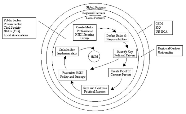
The inter-relationship between the recommendations is shown in the
figure.
In addition two FIG specific recommendations are formulated
ORGANIZATIONS BEHIND THE CONFERENCE
The Conference was arranged and hosted by the
International Federation of Surveyors (FIG), the Institution of
Surveyors of Kenya (ISK), United Nations
Centre for Human Settlements and sponsored by
United Nations Environment Programme (UNEP), Institution of Quantity
Surveyors of Kenya (IQSK) and co-sponsored by Metrocosmo Valuers LTD,
Intergraph Mapping and GIS Solutions,
Swedesurvey AB and University of Nairobi. Support from
United Nations Economic Commission for
Africa (UNECA) and United Nations Food
and Agriculture Organization (FAO).
Further information: fig@fig.net or
jr@kms.dk
THE NATIONAL PERSPECTIVE
NATIONAL ORGANIZATIONS
- NSDI`s are underpinned by effective partnerships and co-operation
amongst a wide variety of multi-disciplinary stakeholders in the public
and private sectors and the end user communities.
African countries are encouraged to form National NSDI Steering Groups
to formulate appropriate policy and institutional frameworks and
facilitate co-operation amongst the stakeholders. These National NSDI
Steering Groups should involve end user representation.
- Experiences from those countries that have embarked on the NSDI
process indicate that roles and responsibilities amongst the
stakeholders are clarified at an early stage.
African countries are recommended to clarify the lead role and the
responsibilities and roles amongst the other stakeholders - this will be
an initial activity of the National NSDI Steering Group.
- It is recognised that the rapid implementation of a NSDI must
embrace all available resources within a country. This will be best
achieved through partnerships between the public and private sectors.
Countries are encouraged to involve all sectors in implementing NSDI and
ensure that appropriate business models are agreed to support these
partnerships at an early stage.
NATIONAL POLICIES, STRATEGIES AND IMPLEMENTATION
- It is recognised that every NSDI is different due to varying
cultural, social and economic contexts within each country. However,
there are a significant number of common elements that can be shared.
Countries should avoid re-inventing these common elements.
- It is recognised that complete policy and institutional frameworks
do not have to be in place before implementation of a NSDI can begin.
- It is recommended that a top down approach is combined with a
pragmatic bottom up approach. Short term bottom up projects will provide
valuable experience and through proof of benefits, convince further
funding of NSDI.
- It is recognised that a mature NSDI will be a complex solution
involving a large number of stakeholders and user groups. From
experience the most effective examples of NSDI`s are those that have
started with clear short term objectives with corresponding simple
solutions.
African countries are encouraged to design solutions that start with
realistic objectives and grow incrementally through political and market
needs.
- The success of NSDI is dependent upon delivering products and
services that are accepted and desired by the end users, both within
Government, the private sector and citizens. This key objective will
only be achieved if the requirements are clearly understood.
African countries are encouraged to provide for end user needs and
ensure that appropriate products and services are provided.
- It is recognised that a key success factor of implementing NSDI is
the management of information as an asset, just as finance and human
resources.
Countries are encouraged to adopt information as an asset and manage it
appropriately, e.g. only capture data that is needed and can be
maintained.
- NSDI requires a culture of data sharing to exist within a country.
Although data may be accessible for the common good, the organisations
providing data must in return receive a benefit for their contribution.
It is recommended that countries research the benefits associated with
data sharing to encourage wide participation.
- It is recommended that all countries establish unambiguous naming
conventions as a key component of their NSD, following the guidelines
produced by the UNGEGN.
LEGAL ASPECTS
- Experience has shown that issues associated with national security,
data privacy and associated liability are potential show stoppers for
NSDI initiatives.
African countries are recommended to establish legal frameworks to
address these crucial legal issues as early as possible.
- Although there will be significant benefits for the data producers
and service providers, it is recognised that one of the main
beneficiaries should be the citizen.
African countries are encouraged to formulate appropriate legislation to
facilitate access to NSDI information and services by the citizen.
- It is recognised that the benefits of an NSDI are significantly
increased if it supports both niche and mass markets.
African countries are encouraged to ensure that the appropriate
legislative business frameworks are established to facilitate support of
mass markets.
CAPACITY BUILDING
- National organisations, with the support of FIG and sister
organisations, are encouraged to organise regular Regional workshops to
raise awareness and knowledge sharing of Spatial Information Management
for Sustainable Development issues and solutions. This will be a
significant contribution to capacity building.
- African countries are encouraged to provide continuous capacity
building. If this is applied at the management level then this will be a
significant contribution to institutional building.
THE REGIONAL PERSPECTIVE
REGIONAL STRATEGIES AND ACTIVITIES
- It is recommended that African countries establish regional
co-operation through joint initiatives that require regional information
management to support common interests. This will encourage knowledge
sharing and ensure common standards are implemented.
- It is recommended that existing Regional centres of excellence in
spatial information review their current services in the context of the
NSDI agenda and ensure that appropriate services are provided to
encourage the establishment and support of NSDIs.
- Universities within Africa should be encouraged to work with the
local survey associations in the provision of Continuing Professional
Development.
THE GLOBAL PERSPECTIVE
UN-ECA AND THE AFRICAN COUNTRIES
- The Permanent Committee for NSDI in the Pacific and South-East Asia
has been successful in promoting co-operation amongst the participating
nations.
The Commission On Developing Information (CODI) proposal for UN-ECA to
establish a Permanent Committee for NSDI in Africa is strongly
supported.
- It is recommended that a sub-group is established under the
Permanent Committee for Africa focussed on the sharing of Education and
Training resources and experiences (Forum of Education and Training).
- Land administration in Africa faces specific, but common elements,
e.g. variety of indigenous right, informal settlements, in relation to
statutory tenure arrangements.
It is recommended that African countries share knowledge and experiences
and develop guidelines within the framework of UN-ECA by the creation of
a forum of land administration as a sub-group of the Permanent Committee
for NSDI for Africa.
- Land administration systems provide important foundation data for
NSDI.
The sub-group of the Permanent Committee for NSDI for Africa (Forum of
Land Administration) is recommended to identify the institutional and
operational conditions for successful land administration in Africa.
- As land tenure in Africa is varied, a good understanding of the
concepts of land tenure and its impact on registration is important.
The sub-group of the Permanent Committee for NSDI for Africa (Forum of
Land Administration) is recommended to aim for a concerted research
effort on this subject.
- It is recognised that ISO (www.iso.org) and the Open GIS Consortium
www.opengis.org produce data and interoperability standards that
should be adopted by NSDI stakeholders.
It is recommended that UN-ECA produce best practice guidelines providing
NSDI implementors with practical advice on how to effectively implement
these essential standards.
TECHNOLOGY TRANSFER - THE ROLE OF THE VENDORS
- It is recognised that the majority of NSDI implementors within
Africa have limited opportunity to be exposed to the technical options
available to build NSDI.
Vendors are encouraged to support a new approach to technology transfer
in Africa.
- It is recognised that many of the key infrastructure requirements of
NSDI, e.g. pervasive, effective telecommunications and Internet access,
are not widely available in Africa. This limits the applicability of
leading edge NSDI technical solutions in Africa.
Vendors are encouraged to understand the needs of African countries and
design and market appropriate technical solutions.
THE FIG PERSPECTIVE
FIG SPECIFIC RECOMMENDATIONS
- There is need for co-operation by FIG (www.fig.net)
Ad hoc Commission on construction economic and management with other
international and regional cost management associations, for research
into cost management and community based driven organisational models
for low cost housing and the publication of the results for
dissemination.
- There is need for FIG to establish a Cross Commission Working Group
to harmonise land management and planning issues with construction and
cost management of low cost housing delivery with holistic requirements
and framework of FIG Agenda 21.
|


