INITIATIVES TOWARD A 3D GIS-RELATED MULTI-LAYER DIGITAL CADASTRE IN ISRAELYerach DOYTSHER, Joseph FORRAI and Gili KIRSCHNER, IsraelKey words: Two-dimensional Cadastre; Three-dimensional Cadastre; Subterranean Cadastre; Land Information Systems; Registration of Land Rights. AbstractThe northern half of Israel, where land is highly utilized, is today one of the most densely populated areas of the world. To enable continued extensive land development, new options need to be found for urban development through more effective utilization of space both above and below the ground surface (as well as beneath the sea). The Survey of Israel (SOI) and the Technion - Israel Institute of Technology initiated in 1996 a joint research and development project, aimed primarily at analyzing the 3D cadastre as a technology base for spatial management and registration of the real estate properties. The rationale of this R&D project was that above and below the ground planning and development activities can be considerably accelerated by guaranteeing the property rights of the owners. At an early stage of investigation, an ad-hoc forum was founded with participation of representatives from both the government and public sectors, as well as from the private sector. Principal activities and field experiments were designated, and a pilot project was completed. A typical test area in the pilot project was composed of built-up facilities situated on the ground, above the ground, and below the ground, all of which were measured in three dimensions. Concurrently, basic geometric and geodetic principles of a three-dimensional cadastre were consolidated, and approval was obtained for the tenet that a thorough and authentic legal investigation is indispensable to this process. A government resolution adopted in Israel in mid-1999, gave a directive for a legal, technical and administrative preliminary investigation of the complex issues of optimizing spatial land use in Israel. According to the resolution, an interdisciplinary expert study is to be prepared and reported to the government by the end of 2001. This task has been assigned to the Ministry of Justice in the role of coordinator. Thus far, a basic legal study has been completed, serving as a guide for both legal and technical experts in this matter. Concurrently, the Survey of Israel is proceeding with evaluation and with securing the necessary budget for technical development and initial practical implementation of a 3D cadastre in Israel in the coming decade. 1. BACKGROUNDIsrael has been undergoing rapid development in recent years, resulting from an increased population, economic growth and a rising standard of living. The population increase, coupled with depleting land resources, has brought into sharp focus the progressive land shortage in the country, primarily in the centers of large cities. Israel is one of the "leading" countries in the West in the growth of built-up areas, infrastructure and environmental nuisances. The developed land area in Israel has been growing in the past two decades at a rate of more than 1% per annum (open land area in Israel has been decreasing by more than 1% each year!). Continued growth of the developed area at such rates and in the current form, will result in the total eradication of open space by the year 2050. The growing population, expected to reach nine million by 2020 and more than thirteen million by 2050, intensifies the need for urgent new solutions in building and developing engineering infrastructures, transportation, water supply, waste removal and preserving open space. One of the ways of coping with the land shortage is to create land reserves for various types of uses, below the ground. The subterranean space is an assured source that is within reach in the near and immediate vicinity. Currently in Israel, just as in many other countries, considerable activity is taking place in subterranean construction, with more development to be expected, due to the solutions that it offers in the area of preserving environmental quality and the quality of life in urban areas. The Government of Israel is of course the principal party interested in three-dimensional land management. The Israel Lands Administration, which administers State land and handles the related transactions, will obtain significant land reserves on a national scale, by exploiting this space. The Ministry of Finance is beginning to take interest in this matter, since it believes that the three-dimensional registration of proprietary rights will promote investment in subsurface and surface projects, leading to higher State revenues by way of taxation. Other clients, such as the Ministry of National Infrastructures, Ministry of Construction and Housing, Ministry of the Interior, Ministry of Environmental Quality, etc., are interested, primarily in the engineering aspects of planning, developing, maintaining and operating subsurface and surface systems in a controlled and proper manner. The Ministry of Justice is dually involved - it needs to develop an appropriate legislative structure for managing the registration of the real estate in this space, and it will be responsible for the spatial registration of the land rights. The Survey of Israel is responsible, by law, as well as by nature, in all matters related to the technical aspects of measurement, mapping and preparing the appropriate technical documentation to support the registration of rights in three dimensions. The government's interest in this subject is most clearly reflected in its decision (1999/144) "Improving Land Use Efficiency", which states that "the Minister of Justice is to submit proposed guidelines for implementing and amending legislation with the aim of facilitating more efficient land use, including subterranean space, and integrating several infrastructures and various applications in a single locality." At the initiative of the Survey of Israel and the Technion, the "Three-Dimensional Multi-layer Cadastre Forum" was established in early 1997, with the participation of representatives of government ministries, the academia, local municipal authorities and private bodies. In recent years the Forum has dealt with the various aspects of transition from a two-dimensional to a three-dimensional cadastre (3DCAD). An initial program was prepared for "converting the cadastre in the State of Israel to an analytical, multi-layer cadastre", and the Survey of Israel is engaged in securing multi-year financial resources for commencing implementation of an analytical two-dimensional cadastre as the first stage, and a three-dimensional cadastre in the following stages. 2. THE CADASTRE IN ISRAELIsrael, as many other countries, has a statutory division of land - the cadastre. Cadastral mapping began in Israel in 1926, based on Torrens (registration of titles) method, with the land unit and its area defined based on official surveying and mapping carried out by the State and linked to the national coordinate grid system. In similar to mapping, which over the recent decades has been gradually undergoing a transition from the graphic sphere to the digital sphere, the cadastre in Israel is now also in transition from the analogue era to the digital era. The changes instituted thus far, and those expected in the cadastre in the future, can be classified into four stages:
2.1 The Analogue CadastreIn the current analog cadastre in Israel (completed over 95% of the country) each administrative unit (village, local municipality, etc.) is divided into registration blocks, with each block divided into parcels. Measurement results are recorded in field books and used to determine the boundaries of the block and the parcels, as well as other features (buildings, fences, electric poles, etc.) on a field plan sheet. Maps of the blocks are prepared based on the field sheet, consisting of scale drawings of all parcels in the block and all included features. These maps contain neither the measured data nor any dimensions whatsoever of the parcel boundaries. The current cadastre in Israel is therefore a "graphic" cadastre in "analogue" form. Most measurements for cadastral mapping were performed by using the chain surveying method. This method necessitates prior marking and measurement of control points in the field (usually a polygon network), and linking these to the national control network. The first blocks in Israel were based on a relatively very low accuracy control network, and what is more, until 1980 the calculation of the polygons was carried out by a separate adjustment of each polygon (the Bowditch method) and not by a rigorous adjustment as a uniform network. Most blocks were plotted manually based on chain surveying measurement, without calculating coordinates. Control of measurement and plotting was carried out by measuring straight distances ("frontages" and diagonals) in the field and comparing them and the same distances as obtained in the drawn map. The quality of the cadastral maps improved with the development of modern measuring instruments and introduction of the polar method in cadastral measurements, while concurrently, new block maps were being drawn by plotters based on calculated coordinates. Another improvement in quality and accuracy of cadastral maps took place in the course of the 1980s and 1990s following the increased accuracy of the national control networks (use of GPS, etc.). In studies conducted in recent years in Israel, considerable discrepancies were obtained between reconstruction of graphic material, compared with calculation from the original field books - a standard deviation of some 0.5m, with the maximum discrepancies greater than 2m. In themselves, such data are not sufficient to define the accuracy level of the current analogue cadastre - yet clearly indicate the scope of the problem that needs to be attended to on the way to the analytical cadastre. 2.2 The Computerized CadastreIn the late 1980s, the Survey of Israel started preparations for the GIS/LIS era. All cadastral blocks (paper maps) are converted into digital form and are entered into the computerized GIS database. The graphic inputting of the analogue block maps is carried out according to defined specifications, primarily: scanning of the graphic material, automatic vectorization of the scanned raster, manual completing and graphic editing by operators (technicians, draftsmen). Within this framework of treating the cadastral data (a project in advanced stages, nearing completion), the graphic quality and accuracy of the blocks is preserved - and therefore the database that is created does not constitute a cadastral statutory validation for the borders of parcels and blocks. According to the Israeli surveying regulations, the renewal of cadastral boundaries is to be performed according to the original surveying data (field books) and not according to the graphic map. 2.3 The Analytical CadastreThe analytical cadastre may be considered as the modern alternative to the traditional cadastre (analogue or graphic/computerized). In the analytical cadastre, every geometric entity, point, line and area, is determined digitally by the State plane coordinate system. The coordinates of each parcel turning point will constitute the evidence for its position and enable its location or marking without requiring physical markings in the field. Thus, analytical cadastre data constitute a spatial information system of data on the statutory division of land. Obtaining digital mapping data for establishing the analytical cadastre creates a bottleneck in establishing the cadastral information system. Several basic sources exist for obtaining such data:
New measurement of all land borders could provide a radical solution of the problem. To this end, it would be necessary to reconstruct borders according to the existing material in the field books and plan sheets, and their measurement according to the new control system, integrating all new surveying techniques (GPS, EDM, photogrammetry). Reconstruction of borders is a tremendous effort in itself, and its cost is estimated to be very high. The cost of subsequently measuring the reconstructed borders is estimated to be similarly high. A possible alternative for reconstructing the borders is to measure the current situation. This solution actually nullifies the entire current statutory validity of the land borders and implements, in practice, a new land arrangement. This solution is not practical in countries that have a statutory land arrangement; and the meaning of this solution in Israel would be eliminating the current cadastre, with all that this involves. The tremendous costs involved in both of the former alternatives, as well as all the additional and administrative significance of such, lead to a conclusion that these solutions are to be rejected and less drastic alternatives are to be sought, involving lower expected costs. Another solution that may be considered is to employ the original measurements based on recalculation of the field books. Calculation of the field books as a stand alone process for establishing an analytical cadastre is not appropriate, due to several reasons, such as: the weakness of the original control system on which the measurements are based and the need to adjust the calculated results to the frontages that appear in the plan sheets. Studies carried out at the Technion in recent years defined a number of solutions using the original measurements, based on recalculation of the field books. Noteworthy among the practical solutions identified thus far in this area, are the following: Computerized Reconstruction of Boundaries in Built-Up Areas This method achieves a ground anchor of the historical measurements in the new network and improvement of their accuracy by adding a limited number of new measurements. The link between the new measurements and the historic measurements is achieved by features in the field. The location of these features will be defined twice, once by means of the old measurements in the old network, and once by new measurements in the new network. The features that need to be re-measured in the proposed system are corners of buildings, since on the one hand, identification of buildings in the field is absolute, while on the other hand, the relative ease of measuring the buildings and the manner of mapping the buildings facilitates integrating the old and new measurements. The accuracy achieved by this system is high (standard deviation better than 10cm) and complies with the accuracy requirements of surveying standards in Israel. Computerized Reconstruction of Boundaries by Photogrammetric Means In view of the fact that the cadastral blocks describe the statutory situation as it was in the past at the time of the cadastral registration, the current land situation in the field usually differs from the cadastral situation defined by the block map. The method is based on comparing the two periods relevant to renewal of the boundaries: the current period - the actual land situation in the field as reflected by current aerial photographs and by land measurements; the previous period - the previous actual land situation (at the time of preparing the cadastral block), reflected both in the block map and in aerial photographs from the same period that reflect the same reality based on the previous Israel control network. The mutual link between all types of data, enables linking the original cadastral observations in the old Israel network to the current control network and reconstruct the cadastral boundaries by computerized means, as a substitute for the physical reconstruction of the boundaries. The accuracy attained by this method in non-urban areas is reasonable (standard deviation at the range of 2-3 decimeters) and is identical to the accuracy obtained by full physical reconstruction of the cadastral boundaries by land measurement. 2.4 The 3DCAD - Problems to be SolvedDevelopment of the 3DCAD involves solving technological-geodetic problems on the one hand, and solving the legal aspects on the other hand. From the scientific and technological standpoint, the principal challenge in developing a three-dimensional multi-layer cadastre lies in gathering, processing and managing the three-dimensional data. The third dimension, which does not appear in the current two-dimensional cadastre, necessitates development of new spatial models for managing the subsurface information and linking it to the surface information. The main tasks in the process of defining and establishing the 3DCAD are: Developing three-dimensional models in respect to the cadastre; Study and understanding of the special character of the subsurface cadastre; and, Creating links between the subsurface cadastre and the surface cadastre. 3. THE PROGRESS OF THE 3DCAD DURING THE LAST YEARS3.1 Basic PrinciplesThe basic principles of the 3DCAD were crystallized during 1996 by the first two authors of this paper, as follows:
3.2 The Establishment of a 3DCAD ForumIn December 1996, encouraged by the director general of the Survey of Israel, a voluntary forum has been established for 3DCAD with a wide range of interested participants: the Survey of Israel (Ministry of Construction and Housing), Technion - the Israel Institute of Technology, the Ministry of Interior, Israel Land Administration (ILA), the Geological Survey of Israel and two other departments of the Ministry of National Infrastructure, the Ministry of Defense and Israel Defense Forces, the Ministry of Justice, the Ministry of Environment, the Municipality of Haifa and two private firms. The main goals of this interdisciplinary forum were (and still are):
3.3 Surveys, Researches and ExperimentsThe Technion, sponsored by the SOI (Survey of Israel), completed a partial literature review. No explicit reports have been found regarding the existence of 3DCAD systems or any development toward a 3DCAD system. The only detailed information about advanced activity (including both technological and legal aspects) has been acquired from Norway (Mr. Helge Onstrud of Statetens Kartwerk, Oslo). Their considerations and results contributed to our further activity. In 1998 a PhD research has been started at the Technion (Benhamu, 1998) entitled "Three Dimensional Multi-layer Cadastre", dealing, among other subjects, with the development of:
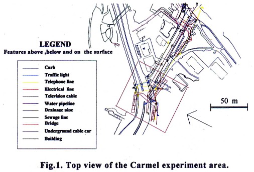
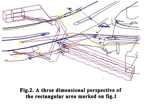
During 1998-1999, a practical experiment of a three-dimensional cadastral measurement (sponsored by SOI and ILA) was completed. As an appropriate site, the Carmel center of Haifa (in the northern part of the country) was selected. Four cadastral blocks compose the site, three of them are still under registration process. A bridge for pedestrians is located in the center of the site above the surface. The upper end-station of the Carmelit subway (connecting the Carmel center on the hill-top and Haifa downtown along the Mediterranean seashore) is situated under the surface. As regular cadastral measurements are completed in two dimensions, special technical guidelines were worked out for three-dimensional measurements. All the surface facilities, the bridge, the buildings and the entrance to the subway were measured by traditional geodetic methods. Most of the underground infrastructure and facilities were mapped by ground-penetrating radar technique (Kovas, 1991), by Israel Institute of Geophysics. All measurements were connected to the New Israeli Grid and to the national vertical control system. A segment of the results is depicted in Fig. 1 and Fig. 2. Lately, Stoter described the 3DCAD experiments in Netherlands (Stoter, 2000). Based on the article, a number of principal similarities can be found between the Dutch and Israeli efforts.
3.4 Government Resolutions and their ConsequencesAn important resolution of the Israeli Government in mid 1999 deals with "Improving Land Use Efficiency". Its approach is mainly judicial, and directs the Minister of Justice - consulting with Ministry of National Infrastructure, Ministry of Interior, the Treasury, Ministry of Construction and Housing, Israel Land Administration and the Survey of Israel - to prepare a proposal for the next practical steps. As a result of this resolution, an initial legal study was prepared covering the legal aspects of the exploitation of the underground space in Israel (Sandberg, 2000), examining the necessity of additional legislation. Another government resolution in mid 2000 ("Land Use Rationalization - Three Dimensional Registration") established a committee headed by the representative of the Ministry of Justice, with the participation of the Treasury, Israel Land Administration, the Ministry of Construction and Housing and the Survey of Israel. The main task of the committee is aimed at the preparation of a proposal for the basic principles of land transactions in three dimensions. The committee should examine the required steps of the realignment by governmental (and other) agencies that are related to the three-dimensional registration of land rights. The authors consider these governmental resolutions as a "no-return-point" in the process of shifting from a voluntary status of the 3DCAD-related activities to a regulative one. 4. LEGAL ASPECTSReviewing the questions regarding the 3DCAD involves a process of evaluating and re-thinking of the basic aims and principles that are the basis of the existing legal cadastre method. This procedure should also include decisions about the mode of change, whether in a "revolutionary" manner or as a moderate reform. The legal base for Israeli cadastral laws (as other parts of the Israeli legal system) was established by the British Mandate. The Israeli Land Law 1) regulates all the main aspects concerning the land such as essence of ownership and other land rights, methods of transferring rights, and registration of rights. 1) The Land Law, 1969. The Land Registration Regulations, 1970. Traditionally (in western cultures), one of the main goals of the legal system is to ensure the free market and guarantee free transfer of properties. When the subject of transactions is land, one of the ways to encourage the commerce is by giving significance to the registration of rights. By doing so, a potential buyer can examine the registration as a preceding step before the deal (confirming the rights of the seller and ascertaining its extent) and subsequently, completing the transaction with the change of the registered owners. Although the foundations of the legal structures are conservative, there is a process of permanent changes in the laws (in Israel as in many other countries), supporting the application of the law to the changing needs of society. This happens by constant changes in the legislation as well as by court decisions. As will be described further, this cautious procedure is more suitable and appropriate for changes that concern property laws. Examining the basis of the land law, this course gains more importance. One of the most important milestones in this process is the enacting of the fundamental Israeli law: Human Dignity and Liberty. Section 3 of the law states the legal right for the protection of property 2) …This makes the protection of the individual rights for property (and land is usually a significant part of it) a constitutional right. The limitations of the right are derived from its constitutional status. Any restriction of the right will be considered justified only if it is for a suitable purpose and is limited in essence. 2) "There shall be no violation of the property of a person." In the current legal status (in Israel as in most of the countries), the right of ownership in a parcel radiates to the center of the earth except for specific laws (regarding water, oil, mines, minerals etc.) and to the sky without preventing the passage in the sky. As can be seen, the legal definition of the rights is open to further limitations. In reality, there are many restrictions to the rights of ownership, some which are obvious and formulated and some that are fuzzy due to difficulties in defining the connected area and describing it in the registration. The implementation of 3D legal cadastre should be regarded as an opportunity for developing the legal rights without a meaningful reduction in any of them. A primary academic study (Sandberg, 2000) is the first stage in the process of remodeling the cadastral laws from a three-dimensional viewpoint. There are many issues needed to be discussed, diverse in their complexity, significance and influence. For example: a decision about the extent of the allowed tolerance for analytical cadastre must be taken and will effect the transition from graphical cadastre to legal/statutory digital one. Special concern must be dedicated to the relationship between neighboring cadastral parcels (or "cadastral spatial objects") in a vertical subdivision, including the formulation of "novel" legal rights: a right of passage for maintenance and repairs, a right for "physical support" and so on. There are also some open policy decisions, for example - will the government (the public) confiscate the ownership of underground layers (levels), or will the principle of ownership be preserved during the legislative process, allowing the future operation of a free market of "cadastral spatial objects". The chances for a "real and essential reform" in the law, enabling better use and development of the limited land resources seem, from the authors' viewpoint, to be good. 5. FUTURE FORECASTSNowadays, the 3DCAD is in the focus of the attention of the government, and the public and the private sectors in Israel. In order for important decisions to be made, the appropriate "marketing policy" must be applied with the support of the professional community. The authors considering the 3DCAD as a national infrastructure believe that this approach should be the central idea of the forthcoming discussions. The interdisciplinary cooperation is essential. In the first stage, the prominent relevant disciplines are: jurisprudence, economy, engineering and geodesy (including cadastre, GIS, surveying and mapping). The authors believe that the jurisprudence has a leading role in the promotion of the 3DCAD idea, and that a basic legislation procedure is necessary. A long list of surveying and mapping tasks have to be undertaken. The two-dimensional cadastre must be completed with height data related to the national vertical control network. The graphical cadastral maps should be transformed and given a legal digital status. Sub-surface must be partially surveyed and mapped in three dimensions, while carefully checked and classified existing documentation (such as plans, maps, etc.) can also be integrated. Special surveying-, mapping- and three-dimensional cadastral regulations and standards must be formed. The establishment of an appropriate registration procedure of rights to land is a joint challenge for geodesists and lawyers. One of the goals of the registration is to achieve an easy and reliable spatial management of the rights to land, thus, perceptible display and easy access to data must be a part of the procedure. New GIS products are under development all over the world, aiming at three-dimensional topology. 3DCAD is expected to be one of the first implementations of this technology. Therefore, the National GIS seems to be an ideal platform for the 3DCAD management. The next decade will be a fascinating one for cadastral experts. Unusual creativity and intellectual effort will be demanded of them for the solution of the challenging three-dimensional tasks, using out the most advanced technology all the time. ACKNOWLEDGEMENTAuthors thank all the people involved in the 3DCAD activity in Israel for their contribution, each one in his or her professional area. Special thank to Mr. Gad Segal for his assistance with the three-dimensional data acquisition and processing during the Carmel Center experiment. REFERENCESBenhamu M., 1998, "Multi-layer Digital Cadastre", A Ph.D. Research proposal, Department of Geodetic Engineering, Technion, Haifa, (In Hebrew). Dale, P.F., 1976, "Cadastral Surveys within the Commonwealth", London, HMSO. Forrai J., Raizman Y., and Gavish J., 1998, "The National GIS in Israel", In Proceedings of GIS OPEN '98, Szekesfehervar, Hungary. Kovas J.E., 1991, "Survey applications of Ground-Penetrating Radar", Surveying and Land Information Systems, 51(3): 144-148. Peled A., Adler R., and Forrai J., 1992, "New Photogrammetric Data, Acquision Data Base for Digital Mapping and GIS", In Proceedings of 18th ISPRS Congress, Washington, D.C. Sandberg H., 2000, "Utilizing Spaces under the Surface of the Earth - Judicial Aspects", A professional opinion presented to the State of Israel, Ministry of National Resources, National Land Administration and Ministry of Justice, April 2000, (In Hebrew). Stoter J., 2000, "Needs, Possibilities and Constraints to Develop a 3D Cadastral Registration System", In Proceedings of 22nd Urban and Regional Data Management Symposium, Delft, The Netherlands. BIOGRAPHICAL NOTEProf. Yerach Doytsher graduated from the Technion - Israel Institute of Technology in Civil Engineering in 1967. He was awarded M.Sc. and D.Sc. degrees in 1972 and 1979 respectively in Geodetic Engineering, also from the Technion. Until 1995 he was involved in geodetic and mapping projects and consultation within the private and public sectors in Israel. Since 1996 he has been head of the Geodetic Engineering Division within the Department of Civil Engineering at the Technion, and currently also heads the Geodesy and Mapping Research Center at the Technion. Published more than 110 original papers in Professional Journals, Conventions Proceedings and Scientific Reports. Supervised more than 30 graduate (PhD/DSc/MSc/MA) students. The Israeli representative to Commission 3 of FIG. Dr. Joseph Forrai was awarded an M.Sc.(1974) and D.Sc.(1980) degrees at Technical University of Budapest, Hungary. Dr. Forrai was Lecturer and Senior Lecturer at TU Budapest, Tel Aviv University, Israel Institute of Technology (Technion) and Bar Ilan University (Tel Aviv) since 1976. Appointments at the Survey of Israel: Chief of Research Division (1987-1992); Head of Photogrammetry Department (1989-1993); Deputy Director General (1993-1994), and Chief Scientist (since 1995). Professional and research background (partial): crustal movement detection; photogrammetric data acquisition (national GIS topographic data base); permanent GPS station network; GPS support for geodynamics. Memberships of the Israeli Society of Photogrammetry and Remote Sensing (president); Association of Licensed Surveyors in Israel; Israeli Cartographic Society. Advocate Gili Kirschner was awarded LLB (1989) and LLM (1996) degrees at Hebrew University, Mount Scopus, Jerusalem. Between 1990 and 1998 worked with several law offices in Israel, engaged with supervision and management of acquisition and registration of dwellings for social residence, legal advice to urban renewal and restoration projects and to real estate developers. Since 1998 fills the legal advisor's position at the Survey of Israel (the governmental agency for surveying, mapping, cadastre and GIS). Member of the Israeli Bar, the Israeli Society of Photogrammetry and Remote Sensing and the Israeli Cartographic Society. CONTACTProf. Yerach Doytscher Dr. Joseph Forrai Gili Kirchner 30 April 2001 This page is maintained by the FIG Office. Last revised on 15-03-16. |