CHANGES IN THE DEFINITION OF PROPERTY: A CONSIDERATION FOR A 3D CADASTRAL REGISTRATION SYSTEMJantien STOTER and Jaap ZEVENBERGEN, The NetherlandsKey words: stratum rights, land registration, multiple land use, 3D registration. AbstractThe Dutch Land Registration Office (the Netherlands' Kadaster) maintains the cadastre and registers the legal status of real estate objects. To be able to do this, the objects (parcels) are digitally stored and maintained in a spatial information system. Until now the spatial information system that is used to register the legal status of land is a two dimensional system: parcels are defined by 2D juridical boundaries. In areas with an increasing pressure on land, there is a growing interest in using space under and above the surface (e.g. underground constructions and infrastructure, growing number of cables and pipes). Therefore, 3D information becomes increasingly important in registering today's world. The current cadastral registration is based on the property relations in a column: the 2D parcel on the surface is the entrance for registration activities. Constructions under or above the surface are divided into parts that match with the parcels partitioning the surface. Establishing rights and limited rights on the parcels generates a horizontal division in the legal status of property. This means that the vertical dimension, which may be important, can not be reflected in the spatial information system and can therefore only be registered administratively (as an attribute of defined parcels). In the Netherlands, a 2D system to register the legal status of real estate objects is no longer sufficient for all cases. Therefore, the Netherlands' Kadaster called for a research to study the 3D issue of cadastral registration in the Netherlands in a fundamental way. This research project is carried out at the Department of Geodesy, Delft University of Technology in collaboration with the Netherlands' Kadaster. During this research the needs, possibilities and constraints to develop a 3D cadastre are examined. The research aims to develop a land information system, which can take into account the juridical relevant spatial information in the vertical dimension in case the situation requires this. It focuses on creating the possibility to define and represent real estate objects under and above the surface as an extension to the current cadastral registration system, which is based on defining and providing information on land in 2D (parcels). This paper contains an analysis of the background of the research project as well as the developed concept of a 3D cadastre. In addition, considerations for the implementation of this concept are described. 1. INTRODUCTIONThe importance of property, and especially of more individualised property rights, grows when the population density increases and land use becomes more intense. Many so-called developed countries have experienced this the last two centuries, and it has been a major drive for the development of cadastral registration systems. Later, pressure on land in urban areas led to the creation of properties on top of each other. Condominium rights have been created to allow for this in numerous jurisdictions, mainly for dwellings (and offices). In the major urban centres (and especially their business districts) land use is becoming so intense, that very different types of 'land' use are being positioned under and above each other. Even when the creation of property rights to match these developments are available within existing legislation, describing and depicting them in cadastral registration systems creates a challenge. This is not surprising when looking at the FIG (1995) description of a cadastre, which focuses on the cadastre being "a parcel-based, and up-to-date land information system containing records of interests in land (rights, restrictions and responsibilities)". When thinking about a parcel, most of us see it as being described by 2D boundaries on the earth's surface. However, that does not satisfy the needs for the more complex multi-layer property situations. Therefore, the Netherlands' Kadaster, responsible for the Dutch cadastral registration system, called for research to study the 3D issue of cadastral registration in the Netherlands in a fundamental way. This research project is carried out at the Department of Geodesy, Delft University of Technology in collaboration with the Netherlands' Kadaster. During this research the needs, possibilities and constraints to develop a 3D cadastral registration system are examined. The aim of the research is to develop a prototype of a land information system, which can take the juridical relevant spatial information in the vertical dimension into account. This paper gives the background of the research as well as the ideas and concepts developed so far. 2. DUTCH CADASTRAL REGISTRATION SYSTEMThe Netherlands' Kadaster is responsible for the cadastral registration in the Netherlands. It is responsible for the registration of the boundaries of parcels (cadastral map) as well as for the registration of the legal status of parcels (land registry). In order to increase the efficiency and to make online network access to the data involved possible, the Netherlands' Kadaster uses a spatial information system with a completely computerised cadastral map for maintaining the geometry and topology of parcels. The legal status of the parcels is maintained in a separate administrative information system. A link between these two subsystems exists through the unique parcel number (Lemmen et al., 1998). Until now, the juridical boundaries used for registration are fixed in 2D space. The whole country is divided into parcels, which are defined in a 2D spatial information system. The parcels are the basis for the registrations done by the Kadaster. The vertical dimension of the legal status of real estate objects, which may be important, is not reflected in the spatial information system and can therefore only be registered administratively. The registration of the legal status of parcels is the only registration of real estate objects in the Netherlands. Building registration does not exist, although research is currently carried out to set up such a registration in the future (Kap and Zevenbergen, 2000). According to the Dutch Civil Code (1992), the right of property of a parcel is not limited in the vertical dimension and hence the property extends to the centre of the earth and into the sky. The right of property comprises the competence to use the land owned. The only exception is that use of space above and under the surface is permitted to third persons, as long as this is done as high or as low, that there is no sense for the owner to object against this use. The definition of property needs reconsideration when separate use of space under and above the surface comes into play. As mentioned before, there is a growing interest in using space under and above the surface, making the vertical dimension an important factor in registering the legal status of real estate objects. To be able to define and manage the juridical situation satisfactory, 3D information becomes increasingly important in the registration activities of the Kadaster. It is expected that the Netherlands' Kadaster will run into registration and maintenance complications in the future. For this reason, the Kadaster decided to carry out a research project on the 3D aspects of cadastral registration. The project aims at creating the possibility to define and represent real estate objects under and above the surface as an extension to the current cadastral registration system, which is based on defining and providing information on land in 2D (parcels). 3. FACTUAL SITUATIONS WITH A 3D COMPONENTFactual situations (situations occurring in the 'real' world), for which it has appeared that the current 2D system is not able to represent the legal status of the situation in the most efficient manner, are:
All these situations have in common that the third dimension is relevant in confirming the legal status of the real estate objects concerned. Apart from apartments, there are no formal rules for registering the legal status, the (2D or 3D) geographical location or the extent of these 3D objects. Although this would give insight in what is situated under and above the surface. This insight would support the definition of rights concerning real estate objects under and above the surface. 4. CURRENT SOLUTIONS IN THE NETHERLANDSThe existence of registration situations mentioned in the previous paragraph has forced the Netherlands' Kadaster to look for ad hoc solutions within the current registration possibilities by means of the available juridical and administrative tools. The solutions have in common that they are administrative solutions, reducing the 3D situations to the partitioning of the country into 2D parcels. The current cadastral registration is based on the property relations in a column: the 2D parcel on the surface is the entrance for registration. A horizontal division in (the legal status of) property is made by the establishment and registration of rights and limited rights on the parcels. As far as Private Law is concerned, registrations of the legal status of parcels in which the third dimension might be relevant are (the Dutch terms are added in italic, between brackets):
Registrations of restrictions dictated by Administrative Law (Publiekrechtelijke Beperkingen) with a possible 3D component, are:
A factual 3D object itself cannot be defined as a cadastral object in the cadastral map and cannot be used as a base for registration. In the current cadastral registration system (with regard to landed properties) a cadastral object is a real-estate object being a complete parcel, part of a parcel or a condominium right. Note that the only real-world objects on the cadastral map are (the contours of) buildings, which serve as a reference framework for the parcel boundaries. In figure 1, the current registration practice is explained with an example.
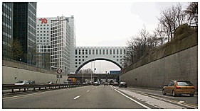
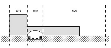
Figure 1. One object (building), three parcels The picture on the right is a sketch of the cadastral situation of the photo. Three parcels are needed to register the legal status of the building. This situation illustrates how property relations in the vertical dimension are registered based on the division of 'the world' in 2D parcels. In figure 2, the cadastral map of the same situation is shown.
Figure 2. Cadastral map of a construction above the surface (see figure 1) The arrow indicates the view position in figure 1. The building is located on three parcels through which the legal status of the building is registered. The firm 'Nationale Nederlanden' possesses the whole building. The rights and restrictions of the parcels concerned are as follows: Municipality possesses a restricted property on parcels 1719 and 1720. 'Nationale Nederlanden' possesses an unrestricted property on parcel 1718, a right of building on parcel 1719 and a right of long lease on parcel 1720. 5. COMPLEXITIES OF THE CURRENT SOLUTIONS IN THE NETHERLANDSThe current registration of the legal status of real estate objects with a 3D component leads to complications (Stoter, 2000):
A system able to reflect the spatial situation could support a more clear definition of spatially complex rights. Management of space under and above the surface will be improved when relevant information on real-world objects (location, function, geometry) is maintained. Besides, a (digital) geographical 3D representation of the situation when needed would facilitate the exchange and supply of valuable information on the factual situation and a better maintainable archive. Standardisation of methods to supply more insight in the factual situation under and above the surface would increase legal security and ease the work of notaries. The concept of a 3D cadastre developed in this research project has been based on these considerations. 6. THE CONCEPT OF A 3D CADASTREThe growing need for maintaining vertical information by the Kadaster is evident. A complete 3D spatial information system would be a solution for the problems met by the Kadaster. However, this solution is too heavy for the purpose that it has to serve since a 3D approach is not needed for all situations. Besides one should not only consider the development of such a system but also the availability of the needed 3D data to make the system operational. Also incorporating the new 3D functionality into the present system, into the work processes and into the present legislation are important factors for contemplation. In order to develop a useful 3D registration system it is important to look at the actual needs of the Kadaster concerning 3D situations. These needs depend on the tasks and responsibilities of the Kadaster which consist of:
Therefore, a spatial solution will be designed to obtain more insight in juridical and factual situations for which the third dimension is important in confirming the legal status of real estate objects. In this research a '3D cadastral system' has been defined as a system, which gives more insight in the juridical and factual situation above and under the surface in case this is relevant with respect to the legal security. This insight is obtained through defining constructions on, above and under the surface as geo-objects in the cadastral system. Whether this definition of real-world objects should and will lead to the juridical registration of these objects remains beyond the scope of this research. Thus, it should be possible to spatially define objects in 3D space. Thereby, attributes of these objects should be maintained in the information system of the Kadaster. The maintenance of implicit and explicit relations between the objects above and under the surface with the parcels on the surface will complete the incorporation of 3D objects in the current cadastral system. An alternative would be the creation, definition and registration of 3D parcels. In the Netherlands, this is not a realistic solution, because the existence of 3D parcels creates some other problems that have to be solved:
Note that the definition of 3D parcels might be useful in some cases (e.g. in case of a condominium right). These cases will be considered in the research project. A relevant question is what kind of detail is required to satisfy the actual needs. A lot of information is already available in 2D (large-scale topographic map, cadastral map). Since (detailed) 3D information is not needed in all cases (e.g. rural land), a system is developed to add 3D geo-objects into the current geo-DBMS (Database Management System) based on 2D parcels. The approach to combine 2D and 3D data in one geo-DBMS, including storage, query and access offers the facility to take the juridical relevant spatial information in the vertical dimension into account when needed (Stoter and Van Oosterom, 2000). In figure 3, the concept of a 3D cadastre, developed in this research, is illustrated. The left of the figure is part of the cadastral map (contours of the parcels), added with the topography of the large-scale map of the Netherlands. The topographic large-scale map, maintained by the Netherlands' Kadaster, is not part of the cadastral map, but a separate geo-dataset. Two (fictive) objects are added: a parking place under the surface and a building above the surface. On the right of the figure, the same map is shown, now implemented in a 3D environment. Insight in space under and above the surface is given by being able to look at the 3D situation under and above the surface. The 3D objects are modelled and defined within the existing geo-DBMS based on 2D parcels. Therefore, it is possible to obtain insight in the factual situation, also in relation to the registration.
Figure 3: the concept of a 3D cadastre In figure 4, the 3D view of the situation is shown in which the surface parcels that intersect with the projection of the two objects are selected. In the cadastral registration, these parcels have a juridical link with the objects in question.
Figure 4. The relation between 2D cadastral parcels and the 3D factual situation 7. THE IMPLEMENTATION OF THE CONCEPT OF A 3D CADASTREThe developed ideas of the concept of a 3D cadastre are translated into prototype implementations. These implementations consist of the whole process:
Collection and preparing 3D spatial information of objects under and above the ground is available with designers, mostly as CAD models (see figure 5). Therefore, it is examined how this information can be used and what conversions and generalisations are needed to obtain the (spatial) relevant information, like the outer boundary of the object. The transformation of a local co-ordinate system to a national reference system is object of special interest. Besides, two possible representations of z-co-ordinates are studied: an absolute z-co-ordinate, defined in the national reference system and a relative one, defined in relation to the surface. When z-co-ordinates are stored in a national reference system, the height of surface parcels is needed to be able to define geometrical and topological relations between the 3D objects and the 2D parcels. In the Netherlands, the horizontal location of a fixed point can be defined in the national reference framework. The Netherlands' Kadaster maintains this framework (co-ordinate system), by means of 6000 points for which the exact location is determined and preserved. The vertical location of a fixed point can be defined in respect to NAP: Normaal Amsterdam Peil (Amsterdam Ordnance Datum). This is the tidal plane of reference used in the Netherlands to measure the altitude of land and structures. The NAP is visible in the landscape by about 55000 marks. These marks are placed in buildings, bridges etc.. Almost everywhere in the Netherlands a mark can be found within one kilometre, which can be used for height determination. The Department of Public works is responsible for maintaining the height marks. The alternative is to collect and measure 3D data, but this can be very difficult in the case of subsurface constructions. The Kadaster should develop work processes and procedures to validate the 3D geo-data generated and supplied by these methods.
Figure 5. Information available at designers can be used to obtain 3D geo-information on real-world objects Storage Besides the collection of data, also the way to model and store the data in the existing DBMS is object of research. For the storage of 3D geo-objects, a data-model will be developed and implemented, consisting of primitives based on standards developed by the OpenGIS Consortium (OGC, 1998) and ISO (2001). This data-model will be incorporated in the current geo-DBMS. Alternatives for this data-model should be extrapolated from restrictions to represent geometric objects in 2D (point, line and/or circular arc, polygon). Possible alternatives for this model are (decreasing in complexity):
Polyhedrons are solids, bounded by flat surfaces with each surface bounded by straight lines. A tetrahedron is a regular polyhedron (faces are congruent: equal in size and shape) with four triangular faces. For further explanation on tetrahedrons and tetrahedral networks see Verbree (1992) and Pilouk (1996). Querying and viewing The incorporation of 3D geo-objects into the existing geo-DBMS based on 2D parcels makes it possible to query the data 2D, 3D and in combination with each other. For example 'find all 2D objects which 'intersect' with (the projection) of a certain 3D object'. From a DBMS point of view, the topology that defines the relationships between 2D parcels and the 3D constructions should be derived by the spatial system. To access the data and to view the results of queries a viewer will be built on top of the geo-database. It will be examined how the data can be viewed administratively, as well as two-dimensionally (traditional GIS interface) and three-dimensionally (perspective, stereo) and in combination with each other in one environment. 8. CONCLUSIONThe Netherlands' Kadaster has the responsibility to register the legal status of real estate objects and to provide this information to customers. The increasing use of space under and above the surface has confronted the Kadaster with the need to define and store information on real-world objects under and above the surface. The right on these objects is still being registered by means of 2D surface parcels. It is important to be able to get insight in the factual situation when the third dimension is a factor in confirming the legal status. Therefore, a system is developed to collect, to model and store, to query and to visualise data concerning objects under and above the surface in combination with the already available data on 2D parcels. With this tool, the Kadaster will be able to perform its tasks more efficiently (and adequately) in case the third dimension comes into play. ACKNOWLEDGEMENTWe would like to thank the Netherlands' Kadaster for their support and input in this research project and professor Peter van Oosterom for reviewing this paper. REFERENCESCivil Code (Burgelijk Wetboek) (1992): Boek 5: Zakelijke Rechten, 1992. (In Dutch.) FIG (1995). Federation International des Géomètres (1995): The FIG Statement on the Cadastre, Publication No. 11, 1995. Kap A.P. and J.A. Zevenbergen (2000): Valkuilen en kansen bij de opzet van landelijke registraties: een (inter)nationale vergelijking, Technical Report, Department of Geodesy, Delft University of Technology, 2000. (In Dutch.) Lemmen, C.H.J., E. Oosterbroek and P.M.J. van Oosterom (1998): New spatial data management developments in the Netherlands Cadastre, proceedings of the FIG XXI International Congress, Brighton UK, Commission 3, Land Information Systems, pp. 398-409, 19-25 July 1998. Pilouk, M. (1996), Integrated Modelling for 3D GIS, Ph.D. Dissertation, March 19, 1996, Enschede:ITC. Stoter, J.E. and P.M.J van Oosterom (2000): 3D registration of real estate objects, proceedings of GIScience, Savannah, USA, pp. 55-58, 28-31 October, 2000. Stoter, J.E. (2000): Considerations for a 3D Cadastre, Delft University of Technology, GISt No. 2, Report to the Netherlands' Kadaster, Delft, October 2000, 30 p. OGC (edited by Buhler, K. McKee, L.) (1998): The OpenGIS Guide, third edition, An introduction to Interoperable Geo-processing, The OGC Project Technical Committee of the OpenGIS Consortium; Wayland, Mass., VS. ISO TC 211 (2001), ISO/DIS 19107: Geographic information - Spatial schema. Final text of CD 19107, International Organization for Standardization, Januari 2001. Verbree, E. (1992), Constructie en Toepassing van het 2-Dimensionale Delaunay Driehoeksmodel en het 3-Dimensionale Delaunay Tetraëdermodel, MSc Dissertation, Delft. BIOGRAPHICAL NOTEThe authors work at the Department of Geodesy, Faculty of Civil Engineering and Geosciences of the Delft University of Technology, the Netherlands. Jantien Stoter is doing a Ph.D. on 3D cadastres, in which the needs, possibilities, and constraints for 3D cadastral registrations are studied. The emphasis of the research is the implementation of the possibility to incorporate 3D real estate objects (geo-objects) in the current geo-DBMS based on 2D parcels of the Netherlands' Kadaster. Jaap Zevenbergen is working in the field of geo information infrastructure in general and cadastral systems in particular with a main focus on juridical and administrative aspects. He has studied and advised on cadastral systems in many countries, in the last few years especially in Central Europe. CONTACTJ. E. (Jantien) Stoter Jaap Zevenbergen 30 April 2001 This page is maintained by the FIG Office. Last revised on 15-03-16. |