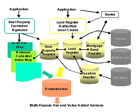
USER INTERFACE AND INTERNET APPROACH - IMPORTANT COMPONENTS IN THE SWEDISH CADASTRAL SYSTEMBo LAURI, SwedenKey words: INTRODUCTIONThe task of the National Land Survey of Sweden (NLS) is to contribute to an efficient and sustainable use of Sweden´s real estate, land and water. We also have the task to develop the service to exploit the potential of existing and new public and commercial markets by meeting the needs of our customers concerning geographic information and land information. The establishing and managing of the Swedish Integrated Cadastral System in Sweden has been a major task for NLS for about 30 years. The system has been in operation for about 25 years and is subject to continuous development. The establishing of the Swedish system was a project that involved several ministries and agencies on central, regional and local levels. Information from the Real Property Register (the Physical cadaster), Land Register (the Fiscal Cadastral) are integrated within the system. The Digital Cadastral Index Map is now also included to the system. The major parts and an overview of the system is presented below:
The system provides all responsible agencies with integrated land information i.e. improves efficiency of public bodies. With support from the system the registration of title and mortgage is done the same day as the application arrives. The system also provides integrated information for multi-purpose use in the whole Swedish society. The information is disseminated on-line, direct to the users by NLS or as value added services by information agents. Integrated information together with the national cadaster index map is accessible via Internet and available for more than 4 million citizens. The Real Property RegisterThe real property register is the basic register on real property. It forms the basis for a number of important activities in society such as land registration, real property credit, property taxation, agricultural statistics, land surveying, population registration and urban and regional planning. The register is maintained by a number of cadastral offices throughout the country. Maintenance of the register is basically a task for national government authorities but there are also 39 municipal authorities (the biggest cities), which have responsibility for maintenance within their own jurisdiction. The Land RegisterThe main purpose of land registration is to give publicity and legal protection for acquisition of rights in real property. An orderly, well-functioning land registration system is a prerequisite for guaranteeing security and facilitating economic transactions. Land Register Authorities maintain the Land Register. NATIONAL CADASTRAL INDEX MAPAll land in Sweden is divided into real property units. There are approximately 3.2 millions such units in the country. The Cadastral Index Map is a part of the Real Property Register and gives the geographical representation of the property. The responsibility for building and maintaining the digital map is on shared responsibility bases between the national government authorities and 39 municipal authorities (out of totally 290 municipalities). There are differences between the cadastral register and the index map in Sweden. The register has a certain standard for the information and it is compulsory for both the national government authorities and the 39 municipal authorities to update the real property register. For the cadastral index map there is up to now no unified standard for the whole country and it is not compulsory for these certain municipalities to update a national cadastral index map database. Last year an agreement between National Land Survey and these 39 municipalities however was made concerning deeper co-operation. The main goal out of the agreement is to build a National Cadastral Index Map (NDRK) covering the whole country. NDRK shall:
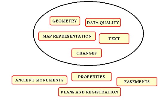
USER INTERFACE 2000The User Interface 2000 (UI 2000) is developed in a project and composed as a concept for interchange of geographical information between first of all the National Land Survey and the Municipalities. The UI 2000 consists of information models, descriptions of transferring mechanism and how they will be administrated and maintained. The interface is not a format or software but a series of technical principles, which can be used for different formats and different data systems. One important demand for the interface is that it will be able to handle all the information in the cadastral index map in Sweden. The content in the Cadastral Index Map, which is regulated in the Register Law, is properties, plans, regulations, easements and ancient monuments.
The interface will in the future be implemented for other kind of geographic information, for example buildings and addresses. UI 2000 gives the new perspectives. It is the objects, for example the plan, easement or the property, which is the base instead of the geometry. These perspectives facilitate integration of the map and the property register. Models of informationThe core in UI 2000 are the models of information i.e. a formal description of the data which will be included in the exchange. Nine models are processed:
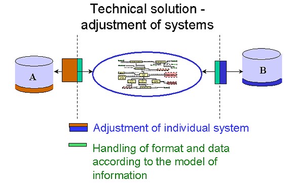
The models are expected to be stable for a long period of time whereas technique and format will change. The models have links to the Land Data Bank System via joint identifiers. The models can handle either whole databases or changes of separate objects. This assumes identifiers, which are unique for the country. The modelling language Express, which has been used is a part of the standard STEP (ISO 10303). Format and applications for data transmissionUI 2000 consists besides models of information, of specified file format and an application for data transmission. These three parts are independent of each other and are possible to change and further develop separately. Technical solutionThe specification for UI 2000 does nor describe how it shall be connected to sending or receiving system or how the agreed model shall be translated to different internal models which exists. There is a demand for a unique solution for each system, which has to be taken out by each organisation together with their system supplier. But there are some basic criteria for each system, which has to be fulfilled. The systems have to be object oriented, be able to make controls of data structure and also handle changes of objects.
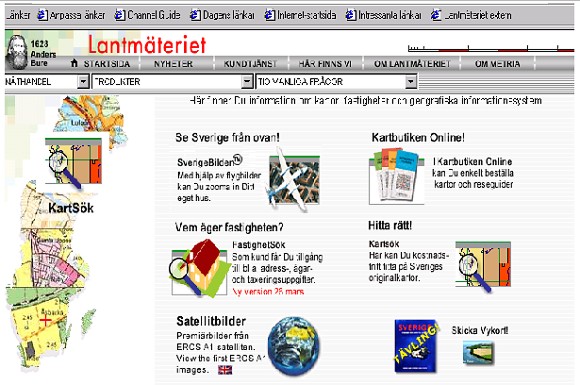
ImplementationThe implementation of the UI 2000 now takes place in a pilot project, where one municipality together with NLS are building a test environment for a general evaluation of the interface. This phase of the project will be completed during autumn this year. The UI will thereafter be implemented for all municipalities INTERNETNLS has launched new Internet service View and buy maps and detailed aerial photos of all of Sweden. It is an e-commerce site where visitors can view and buy aerial photos and maps and search for individual properties Viewing is free of chargeAerial photos covering the whole of Sweden can be viewed free of charge on the web site. You only pay if you wish to order a photo. The photos taken over Stockholm, Gothenburg and Malmö are so detailed that you can see people in them. In the aerial photos of the rest of Sweden, you can distinguish cars. But the site contains a lot more than aerial photos. A map shop, is also included in the new site and will gradually be expanded to include more products. Since January, NLS has offered a well-stocked shop with maps, atlases and nautical charts. Services for estate agents and bankswww.lantmateriet.se also provides two services especially designed for estate agents and banks, etc. These services are called 'FastighetsSök' [property search] and 'KartSök' [map search], and enable users to obtain information on the owners, tax value, addresses, etc. of a particular property by giving an address or clicking on a map. To use these services, you first need to sign an agreement with the National Land Survey of Sweden. The e-commerce site is in Swedish only.
CONTACTBo Lauri 12 April 2001 This page is maintained by the FIG Office. Last revised on 15-03-16. |