ON THE NEW NATIONAL GEODETIC DATUM 2000 IN KOREAProf. Hongsic YUN, KoreaKey words: Primary Precise Geodetic Network (PPGN), Korea Geodetic Datum 2000, ITRF97, GRS80, GPS fiducial network. AbstractThe first nationwide geodetic network in the Korean peninsula was established in 1910-1915 by the Bureau of Land Survey, the Government-General of Korea in cooperation with the Japanese Military Land Survey. The major network of the old triangulation consisted of thirteen baselines, primary and secondary networks, and were connected to the Tokyo Datum with the triangulation through Tsushima Islands. After the World War II, the network over the Korean straight (Tsushima straight) was resurveyed in 1954 by US Army Map Service Far East in cooperation with Geographical Survey Institute of Japan, in order to strengthen the connection between Korea and Japan. To keep consistency with the old coordinates system, the PPGN was adjusted in the way that its official coordinates are same as the old ones. Unfortunately, original records of the old survey are lost during the Korean war, and we only have a set of coordinates of triangulation points now. The establishment of Primary Precise Geodetic Network (PPGN) was carried out in 1975-1994 by National Geography Institute of Korea. The PPGN consists of 1155 points including 175 (~15 %) old first- and second-order triangulation points (normal points) not damaged by the war, and its mean side-length is about 11 km. The coordinates of PPGN derived in 1995 have been held fixed since. During the 1980's and 1990's the increased use of satellite based geodetic measuring systems - such as the GPS - began to impact on the utility of the national geodetic datum in Korea. Under this impact, new geocentric datum, new Korean Geodetic Datum 2000 (KGD2000), designed and built during 1998, is realized through ITRF97 and used the GRS80 ellipsoid. A description of the new datum, its design, implementation and GPS fiducial network will be described. 1. GEODETIC WORKS IN THE KOREAN PENINSULAThe first geodetic datum used in Korea was the Tokyo datum of 1892 where j 0= 35° 39¢ 17.515² North, l0=139° 44¢ 30.097² East of Greenwich. The defining azimuth was determined from the old Tokyo Observatory at Azabu to station Kanoyama (Kano Mountain) as : L 0= 156° 25¢ 28.44² . The Tokyo Datum of 1892 is reference to the Bessel 1841 ellipsoid where the semi-major axis a = 6,377,397.155 meters and the reciprocal of flattening 1/ f = 299.1528128. The Tokyo datum of 1918 was later adopted for use in Korea, but the cadastral grids were not changed to accommodate that new system. The only difference between the two datum is that in 1918 re-determination of longitude established l 0 = 139° 44¢ 40.502² East of Greenwich, which is an increase of 10.405² . In Korea, the geographic coordinates of the triangulation stations are on the Tokyo datum of 1918, but the grid coordinates are on the Tokyo datum of 1898. This is little-known fact about Korean mapping that has led some cartographers to question their own sanity! Geodetic survey in Korea started in 1910 by the Bureau of Land Survey, the Government-General of Korea with the cooperation of the Japanese Military Land Survey, and was completed by 1918. The old triangulation network consisted of thirteen baselines, primary and secondary networks, and it were connected to the Tokyo Datum with the triangulation through Tsushima Island in 1940. Unfortunately, the Korean War virtually destroyed about 85% of the existing triangulation stations. The origin of Korea datum in 1985 was established at Suwon station in the ground of the NGI where j o=37° 16¢ 31.9034² North, l o=127° 03¢ 05.1451² East of Greenwich. The defining azimuth to station Donghak-san is: L o=170° 58¢ 18.190² . The reference ellipsoid is the same as the existing Bessel 1841. The 40 Lapalce stations established for this new datum were planned for a density of one station per 5,000km2. In 1996, 37 Laplace stations were observed. The establishment of Primary Precise Geodetic Network (PPGN) has carried out from 1975 to 1994 by the NGI of Korea. The PPGN consists of 1155 points including 175 (~15%) old first-and second-order triangulation points (normal points) not damaged during the Korean War, and its mean side-length is about 11 km. NGI (1994) conducted the simultaneous network adjustment of PPGN fixing a certain number of the normal points, in order to keep new coordinates consistent with those of old surveys. Whilst the existing datum is uniform and consistent across Korea, positions are not directly compatible with those displayed by satellite receivers. In 1998, NGI was, therefore, decided to adopt the new geocentric datum referred to ITRF97 to meet the requirements of various users in 21st century. The replacement Geocentric Datum of Korea is compatible with satellite positioning and therefore necessarily introduces changes to all existing Datum latitude and longitude values by an amount equivalent to a shift on the ground of about 600 meters. In Korea, NGI has utilized satellite surveying techniques since 1979. Satellite surveying has been performed at Pusan, Kyeongju and Cheju Island using two Magnavox 1502 receivers through cooperation with Geodetic Surveyor Institute of Japan until 1982. Twenty islands have been occupied for Transit Satellite observations as of 1991. Since 1991, NGI has used GPS receivers to strengthen the PPGN and the Precise Secondary Geodetic Network. NGI has established 14 permanent GPS sites in a continuously operating reference station network started with the first station called SUWN using a TurborogueTM SNR-8000 receiver on 15 March 1995. Currently, fifty permanent GPS sites operated by other divisions had established for the purpose of cadastral surveying, geodynamic application and atmospheric research. The most interesting recent developments in the field of precise positioning with GPS are the establishment of permanent GPS arrays (PGS’s) and the widespread use of GPS for fast and precise positioning. PGA’s are mainly used for geodetic, geodynamic and atmospheric research. In the past ten years a large number of permanent GPS arrays were established. Global PGA’s are used for the determination of GPS orbit and related parameters. The global PGA of the International GPS Service (IGS), which consists of more than 200 tracking stations, nowadays provides post-processed orbits at the 5 cm level with a delay of two weeks. National and regional PGA’s are used primarily for high-precision geodetic and non-geodetic applications, such as reference frame maintenance, monitoring of sea level rise, crustal deformation monitoring and estimation of atmospheric parameters (Jong, 1999). This paper gives a full description of all the service related to the KGD2000, the KGFN and the official coordinates based on 11 day solutions will be discussed. 2. ADOPTION OF THE KOREAN GEODETIC DATUM 2000Korea has adopted a new geocentric datum as its national datum, Korean Geodetic Datum 2000(KGD2000), to replace existing Korean Geodetic Datum. This is a semi-dynamic datum with coordinates aligned to the International Terrestrial Reference Frame 1997 (ITRF1997) at a reference date of 1 January 2000.0(epoch 2000.0). This adoption will allow closer integration with international coordinate frameworks, navigation systems, scientific applications and routine spatial data management. KGD2000 was officially released on 1999. The new datum provides an accurate spatial infrastructure in Korea for the 21st century. The characteristics of KGD2000 are:
The advantages of the new datum (KGD2000) are that:
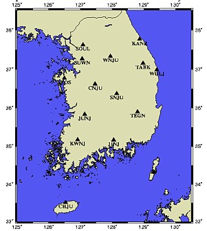
3. ESTABLISHMENT OF CONTINUOUS OPERATING GPS FIDUCIAL NETWORKDuring 1996 and early 2000, National Geography Institute established a national network of permanently installed, continuously observing, automatically communicating GPS stations in all parts of Korea - the active stations of the National GPS Network. The complete network includes about 61 active stations, of which about eleven are owned by NGI, and the remainder operated by other government agencies working in partnership with NGI. The active stations are deployed such that any point in Korea, including Cheju island, will be within 30 km of the nearest active station. The active stations are installed with dual-frequency geodetic quality receivers, mostly with choke ring antennae to minimize the effects of multi-path on a ground plane. Each site collects data at 30 seconds and communicates automatically data by a ISDN/PSTN lines to NGI's master control center. This central computer downloads data from each station every hour and monitors the health of the system. At NGI, data are validated, converted to RINEX format and processed using Berness software. All the Korean GPS fiducial network receivers are remotely controlled from SUWN master station. The daily acquisitions of the Korean GPS fiducial network are checked and archived at SUWN. A data quality check, using the UNAVCO QC v3 software is done periodically in order to verify the correct functionality of the Korean GPS fiducial network receivers. Daily precise ITRF97 coordinates of all active stations are computed weekly by NGI and used to monitor the positional stability and data quality of each station. Yun (2000) performed a time series analysis of SUWN site. For high accuracy surveying, NGI recommend the use of IGS precise satellite orbits (ephemerides) rather than the RINEX navigation files supplied with the active station data. These are available from IGS web site. The solution is performed about ten days later data collection, in order to use IGS products (rapid or final precise orbit and associated Earth rotation parameters). Figure 1 shows the lay-out of the Korean GPS fiducial network. Figure 2 shows the typical type of permanent GPS station established by NGI.
Figure 1. Lay-out of the Korean GPS fiducial network established by NGI
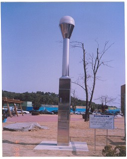
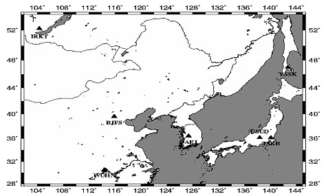
Figure 2. Typical type of permanent GPS site established by NGI 4. DATA ANALYSIS USING THE GIPSY/OASIS II SOFTWAREGPS data processing includes the review and cataloging of collected data files, processing phase measurements to determine baseline vectors and/or unknown positions, and performing adjustments and transformations to the processed vectors and positions. Each step requires quality control analysis, using statistical measures and professional judgment, to achieve the desired level of confidence. Each of these steps is also very dependent upon the measurement technique, the GPS receiver and antenna types, the observable recorded, and the processing software. The analysis strategy adopted for this study is the so-called fiducial approach. In this concept, the positions of a minimum of seven selected sites in the network are held fixed at their a priori values, while coordinates of the other stations and the GPS satellite orbits are adjusted. Thus, the solutions of the other sites are tied to the reference frame defined by the seven fixed stations. For this study, a fiducial network consisting of Tsukuba, Sanghai and Wuhan was selected. The reason that it was chosen is because these stations have the best SLR or VLBI observations, and are therefore assumed to have the most accurately determined station coordinates. For the data analysis, GIPSY/OASIS-II has used. At JPL, the GIPSY/OASIS which it had not been used extensively during the last few years to analyze GPS carrier phase and pseudo-range data from many experiments, yielding baseline precisions at the level of a few parts in 109 or better (Lichten and Border, 1987; Tralli et al., 1988). The GAMIT/GLOBK is used to adjust the GPS fiducial network using the results of baseline analysis obtained from GIPSY/OASIS. Data processing started with the automatic editing of the GPS data. This included elimination of bad data points and cycle slip detection and repair, when possible. The first set of ITRF values were computed using 11 days (9th November, 2000 - 20th November, 2000) at 14 permanent GPS sites. This work was used a processing strategy compliant with IGS standards. The nearest seven IGS sites (Tsukuba, Beijing, Daejun, Wuhan, Usuda, IRKT, YSSK) are constrained in the solution that use the IGS products (precise ephemeredes, orientation parameters and coordinates) to produce results with an accuracy of a few centimeters. Figure 2 shows the location of IGS sites used and Table 1 shows the coordinates of seven IGS sites.
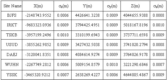
Figure 2 Locations of IGS sites used Table 1. ITRF97 coordinates of IGS sites
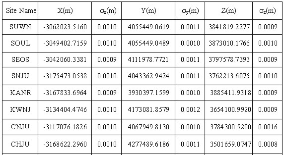
For each site eleven-day mean was computed from continuous daily GPS solutions. Daily output solutions included a vector of all estimated parameters and a full covariance matrix of errors. The daily position estimate vectors and covariance matrices were combined to yield one final position estimate vector and covariance matrix. The coordinates computed in terms of ITRF97 at epoch 2000.343 for the Korean GPS fiducial network as shown in Table 1. The cartesian components of each site position has small error, 1 mm for x, y and z, which were highly correlated. Table 1. ITRF97 coordinates at epoch 2000.
5. DISCUSSION AND CONCLUSIONSIn this study, new Korean Geodetic Datum 2000 (KGD2000), designed and built during 1998, is realized through ITRF97 and used the GRS80 ellipsoid. A description of the new datum, its design, implementation and GPS fiducial network were described. Korean Geodetic Datum 2000 is a significant step forward in meeting Korean future spatial positioning needs. The alignment with the ITRS ensures compliance with international standards. This paper has also presented the results of an analysis of the Korean GPS fiducial network data. The KGFN will give lots of opportunities for scientific investigations in Korea. Crustal deformation study are primarily supported: a more accurate velocity field will be deduced with longer time series of the stations coordinates. The KGFN matches also with other applications such as atmospheric studies, navigation and civil services. REFERENCES
CONTACTAssociate Professor Hongsic Yun 14 April 2001 This page is maintained by the FIG Office. Last revised on 15-03-16. |