Contribution of Hydrography towards Sustainable Water ManagementFIG Commission 4: HydrographyM.R. Mahmud, N. Hewitt, G. Johnston, S. Ironside and A.H Omar "The 2019-2020 year has been a busy one with the Working Groups of Commission 4 focussing on representing FIG at a number of events and forum to gain insight to develops generally and also to deliver and present on the work of FIG. Through all its Working Group, Commission 4 has been actively involved in implementing its policy by working in close cooperation with relevant organisations and institutions."Altogether there are four (4) Working Groups for Commission 4 as listed below: WG 4.1 – Standards and Guidelines for
Hydrography The Chairs for WG 4.1 is Mr. Neil Hewitt, WG 4.2 is Mr. Gordon Johnston, WG 4.3 is Mr. Simon Ironside and WG 4.4 is Dr. Abdullah Hisam Omar. While WG 4.1, WG 4.2 has been in existence for some time, WG 4.3 and WG 4.4 are new in Commission 4. Also, the Chairs of WG 4.1 and WG 4.4 are new to Commission 4.
Work PlanThe Blue Economy is important as it provides a vital
source of food and benefits from a host of industry
sectors, technology and innovation. It can provide a
valuable Return On Income (ROI) for investors. The
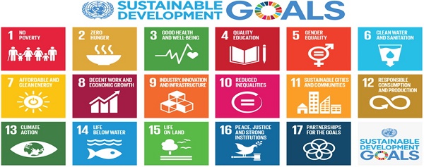
UN SDG’s, especially SDG-14 cannot be obtained
without a much more systematic survey coverage of
our oceans. The GEBCO Seabed 2030 project has this
objective. The pressures on limited ocean and sea resources
continue. Resilience to the impact of man, climate
or natural disasters needs to be developed and
enhanced. Fifty years ago the Ocean was considered
non-finite and extractive. Today the Ocean is
finite, considered an ecosystem that requires
management to enable Ocean Health to be sustainable.
These are real challenges. Relating the SDG’s to aspects of the Blue Economy: It is an enormous, growing market Fundamentally:
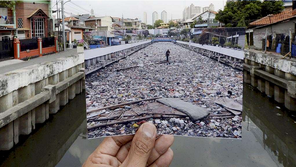
The effects of plastic pollution on the Earth’s oceans are well documented, potentially catastrophic and increasing exponentially year on year. The UN Environment Programme (UNEP) has calculated that only nine per cent of the nine billion tonnes of plastic produced throughout the world has been re-cycled and each year more than 8 million tonnes of plastic come to reside in our oceans. Eighty per cent of all litter in our oceans is made of plastic. This is an intolerable problem that needs immediate and far-reaching action to remedy. Eric Solheim, Head of UN Environment, speaking at the launch of the #CleanSeas campaign argued that it was past time to tackle the plastic problem that blights our oceans. ‘We’ve stood by too long as the problem has gotten worse’ he said, ‘it must stop’. We agree. Rivers have been identified as a significant contributor to, and enabler of, the plastic pollution problem affecting our oceans. UNEP estimates that just ten major river systems carry more than 80% of the plastic waste that ends up in the Earth’s oceans. Much of the available information relating to the scale of the plastic pollution problem is based on relatively crude modelling. Plastic litter is predominantly concentrated on banks, coastal beaches and in the upper limits of surface water bodies. The lack of a means of comprehensive analysis of the spatial and temporal extent and quantum of plastic waste at a specific site, or on a regional or global level and the tools for ongoing monitoring represents a significant obstacle to addressing and eradicating the plastic waste ‘explosion’. As surveyors and spatial professionals, we have the requisite skills and expertise to determine the vectors, quantum and frequency of plastic passing through waterways and to accurately quantify the amount and type of plastic litter on riverbanks, coastlines and estuarine areas. Remote sensing data from satellites and airborne platforms available in different spatial, spectral and temporal resolutions has the potential to be a reliable source of long-term qualitative and quantitative information over large geographic areas. Research by members of the Mapping the Plastic working group at universities in Bosnia and Hezegovina and Serbia are currently underway to distinguish plastics from surrounding litter/debris classes using remote sensing techniques and the results are very promising. Assessment of the spatial extent and variability of plastic is possible due to the unique spectral signature of polymers in the near-infrared part of the electromagnetic spectrum and we are looking at defining the data acquisition technology and identification methodology that will enable identification of plastic debris down to 1 cm2 in size. A combination of high resolution satellite and drone data has been processed using the developed algorithms to detect floating plastic in surface water, combined with ‘ground truthing’ land surveying measurements, bathymetric and water current data. This data will enable teams of volunteers to accurately map plastic concentrations at global ‘hot spots’ to enable regulators to better understand the extent of the phenomenon they are dealing with and inform decisions that impact the potential solution. The Commission 4 FIG Working Week 2020 Technical Session on Mapping the Plastic is dedicated to the study on plastic pollution problem affecting the ocean (TS03F).
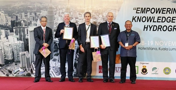
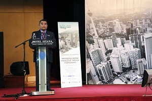
In order to undertake the field work required to infill gaps in the satellite/drone data, Trimble has kindly donated a suite of surveying hardware and software to the Mapping the Plastic working group and on behalf of FIG, Commission 4 would like to express our gratitude to Trimble for their assistance. This equipment will be of enormous benefit and is greatly appreciated. Negotiations are ongoing to secure a drone to assist with the plastic surveys. The management of good governance of marine space administration has been debated since at least the 2000s. An extensive literature and research report, it is hardly surprising that this marine space is under serious threat from a myriad of overlapping and conflicting interests, where the evidence of change is compelling and manifest. Therefore it is imperative to manage, administer and govern the coastal zone in a considerable, sustainable and structural manner as well as to protect and nurture the environment we live in. Failure to do so may have disastrous consequences for future generations. This includes polishing the management system, particularly the governance of marine space administrative to support marine rights. Marine space administration and management can help to improve our governance and information systems on coastal and marine areas. Marine managed areas, in the widest sense, are geographic areas designed to protect or manage resources within the marine environment. Any agency that has jurisdiction in the marine environment can create marine managed areas. Framework of marine development and administration comprise of institutional, technical and socio-economic components. The entities of the framework will include custodian, implementers, technical support and data centre, policy, stakeholder, facilitator and source of human capital. CooperationThe work of the International Board on the Standards of Competence of Hydrographic Surveyors and Nautical Cartographers meets annually to both review submissions from academic and naval institutions. The ten Board members are distributed world wide so the only practical way to review and maintain the course submissions and the Standards involves a two week annual Board meeting plus the inter-sessional reviews of some 16-18 courses. A good summary of the work of the IBSC is included in the 2018 IHR International Hydrographic Review published paper, https://journals.lib.unb.ca/index.php/ihr/article/view/26298/1882519051 The Commission 4 maintain a seat on the Capacity Development Forum that includes the IHO, IALA, WMO, IOC, IAEA, and IMO. It meets once a year in Europe and reviews potential opportunities to collaborate on possible development projects and campaigns. The (anti) plastics ‘movement’ world-wide is dynamic, motivated, concerned (verging on angry!), well informed and growing rapidly. The problem is huge, if not overwhelming, and one of the things the surveying profession has learned is that forming alliances with groups within the plastics movement is the most effective way of directly influencing positive outcomes. It also enables the profession to understand where and how we can contribute most effectively. The 2019 FIG Working Week in Hanoi, Vietnam was an opportunity to form a relationship with GreenHub- a young, dynamic and green Vietnamese NGO, and Australia’s Commonwealth Scientific and Industrial Research Organisation (CSIRO) who are doing great work in the plastics field. GreenHub and CSIRO have undertaken a large plastic survey along the coastline near Hanoi and attendees were fortunate that these organizations were able to present the results of their survey at the Mapping the Plastic session in Hanoi. A representative of the Vietnamese government presented a rather gloomy picture of Vietnam’s plastic problem and World Bank representatives in attendance expressed interest in uses of the plastic detection algorithm the working group have developed, particularly the ability to identify individual plastic manufacturers. One of the ‘hot spot’ areas the working group would like to survey with GreenHub and the Vietnamese government is the Mekong Delta in the south of Vietnam (TS03F). Unfortunately, there are no shortage of hotspots that require attention. ActivitiesAnnual Meeting of FIG Commission 4An annual meeting of Commission 4 was held in Kuala Lumpur, Malaysia in conjunction with the conference “KL GeoHydro 2019”. All four (4) Working Group Chairs attended the meeting held on 18 November 2019. Conference & Exhibition “KL GeoHydro 2019”The event was held in Kuala Lumpur, Malaysia for two days from 18-19 November 2019. FIG is the main organiser for this event together with The Association of Authorised Land Surveyors Malaysia, Royal Institution of Surveyors Malaysia, Land Surveyors Board Malaysia, Department of Survey and Mapping Malaysia, National Hydrographic Centre Malaysia, Universiti Teknologi Malaysia and Malaysian Hydrographic Societies. All four Working Group Chairs including the Chair of Commission 4 gave a presentation in the event. The topics of presentation by the WG Chairs are as follows: Hydrographic Survey Certification (WG 4.1), Blue Growth, Developing the Blue Economy and the Surveyors Contribution (WG 4.2), Mapping the Plastic – A Surveyor’s Response (WG 4.3) and Roles of Marine Cadastre for Nation Development: Potential, Requirement and Challenges (WG 4.4) (KL GeoHydro 2019). Highlights of Commission 4 Technical SessionsAltogether, there are 18 papers dedicated to Commission 4 including two (2) Joint Sessions with Commission 5 and YSN. The sub-theme on Smart Surveyors comprised of four (4) papers with 14 papers related to Integrated Land and Water Management. TS02F: HydrographyThe session comprises of general topic on hydrography such as processing of big data for 3D multibeam sonar and Lidar point cloud, and e-Learning oriented hydrography programme. TS03F: Mapping the PlasticWorking Group 4.3, a combined initiative of the FIG Young Surveyors Network (YSN) and Commission 4, focusses on the dumping of plastics (and other waste) into major rivers, river systems and deltas at strategic locations around the world. TS04F: Hydrographic SurveysThis technical session comprises of topics in tidal studies, technique in hydrographic survey measurement, using low cost bathymetry system and satellite derived bathymetry method. Tidal plays an important role in hydrographic measurement activities especially in determining the sounding datum and reducing the depth measurement. TS05F: Hydrography ContributionThe session focuses on topics where hydrography contributed to the various activities in educational development, sedimentation monitoring, water operations and mapping the plastic. ConclusionPre-collaboration between ASEAN educational institution (Malaysia and Indonesia) and non-government organisation such as World Wide Fund for Nature (WWF) on marine administration and marine space management is a promising opportunity towards the development and implementation of marine cadastre and marine administration framework to all other members in FIG. Since it’s inception at the FIG Congress 2018 in Istanbul, Mapping the Plastic, a joint undertaking of Commission 4 and the Young Surveyors Network, has been very active and there is every indication that it’s workload will only increase. It has been formed to better understand plastic pollution in waterways by providing accurate and reliable information of the magnitude of the problem at source, thereby highlighting unsustainable practices, identifying infrastructure shortcomings and informing robust land use controls with the ultimate goal of eradicating the dumping plastic waste into rivers.
|
|||
 |
Prof. Dr. Mohd Razali Mahmud, |
||
Further readings:FIG Working
Week 2020 Proceedings FIG Commission 4 Sessions:
FIG Commission 4 website: |
|||
 #FIG2020 /font>> |