News in 2020
|
FIG and MAPPING THE PLASTIC - Background and Mapathon
In 2019 at the FIG General Assembly in Hanoi, Vietnam FIG Commission 4 -
Hydrography together with
FIG Young Surveyors
established a Working Group on Mapping the Plastic. The
Working Group is chaired by Simon Ironside, New Zealand
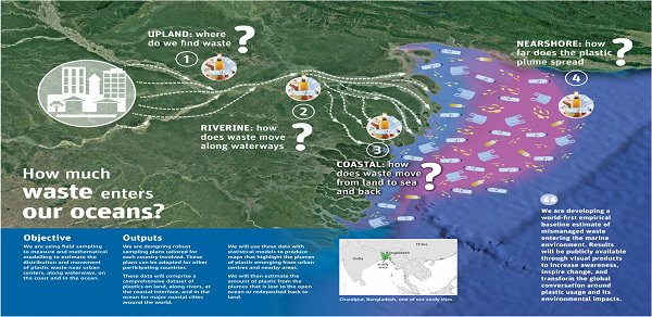
and focus is on the dumping of plastics (and other waste) into
major rivers, river systems and deltas at strategic locations around the
world. Waste measurement in these water bodies using remote sensing,
bathymetyric, current measurement and topographical surveys of plastic
waste along the banks of rivers will enable a greater understanding of
the quantum of plastic waste being transported to the oceans and inform
the control and regulation of land use practices with an ultimate goal
of eradicating the dumping of plastics into river systems.
The Working Group has been busy and continues to be. In conjunction
with the FIG Working Week in Amsterdam a
Plastic Mapathon and Plastic Survey
will be held Saturday 9 and Sunday 10 May 2020. The goal is to
investigate the extent of existing information on plastic pollution of
waterways in the Netherlands/Europe through formal survey datasets held
by governments and academia and to develop techniques for collecting
this information. For more information and
to register, please visit
www.fig.net/fig2020/plastic.htm
Gordana Jakovljovic, a Young Surveyor and Ph.D. student will make a
plenary presentation: Mapping plastic –
the step forward for a cleaner environment during the FIG Working
Week. Gordana will examine the developed methodology and results of the
identification of floating plastic by using remote sensing and
geospatial technologies. Produced maps should be used as a base for the
creation of action plans for removing plastic from the environment.
For more information about the FIG Working Week, please visit
www.fig.net/fig2020/
The background
This text is based on an article published in GeoConnexion
Magazine
By Simon Ironside, Chair of FIG Commission Working Group 4.3
The effects of plastic pollution on the Earth’s oceans are well
documented, potentially catastrophic and increasing exponentially year
on year. The UN Environment Programme (UNEP) has calculated that only
nine per cent of the nine billion tonnes of plastic produced throughout
the world has been re-cycled and each year more than 8 million tonnes of
plastic come to reside in our oceans. Eighty per cent of all litter in
our oceans is made of plastic. This is an intolerable problem that needs
immediate and far-reaching action to remedy. Eric Solheim, Head of UN
Environment, speaking at the launch of the #CleanSeas campaign argued
that it was past time to tackle the plastic problem that blights our
oceans. ‘We’ve stood by too long as the problem has gotten worse’ he
said, ‘it must stop’.
The surveying profession agrees. The International Federation of
Surveyors (FIG) represents the interests of surveyors in over 120
countries. Through a combined initiative of FIG Young Surveyors Network
and Commission 4 (Hydrography), FIG has formed a Working Group (WG
4.3)on Mapping the Plastic to better understand plastic pollution in
waterways by providing accurate and reliable information of the
magnitude of the problem at source, thereby highlighting unsustainable
practices, identifying infrastructure shortcomings and informing robust
land use controls with the ultimate goal of eradicating the dumping
plastic waste into rivers.p>
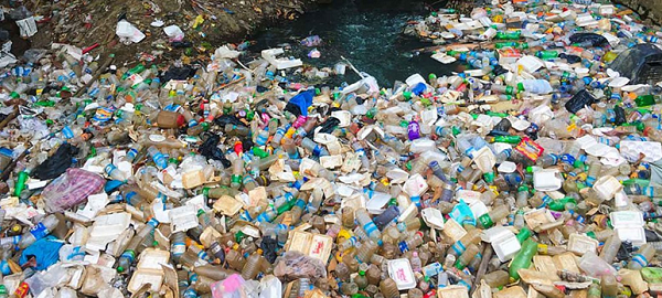
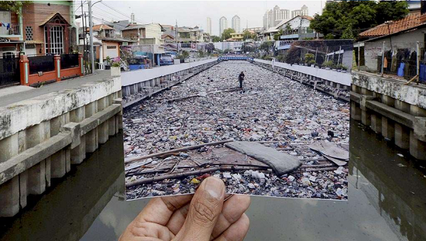
Rivers have been identified as a significant contributor to, and enabler
of, the plastic pollution problem affecting our oceans. UNEP estimates
that just ten major river systems carry more than 80% of the plastic
waste that ends up in the Earth’s oceans. Much of the available
information relating to the scale of the plastic pollution problem is
based on relatively crude modelling. Plastic litter is predominantly
concentrated on banks, coastal beaches and in the upper limits of
surface water bodies. The lack of a means of comprehensive analysis of
the spatial and temporal extent and quantum of plastic waste at a
specific site, or on a regional or global level and the tools for
ongoing monitoring represents a significant obstacle to addressing and
eradicating the plastic waste ‘explosion’.
As surveyors and spatial professionals, we have the requisite skills and
expertise to determine the vectors, quantum and frequency of plastic
passing through waterways and to accurately quantify the amount and type
of plastic litter on riverbanks, coastlines and estuarine areas. Our
response to this problem is to provide accurate and repeatable data at
specific locations to assist regulators and better inform land use
control decisions.
Our Response To The Problem
Remote sensing data from satellites and airborne platforms available in
different spatial, spectral and temporal resolutions has the potential
to be a reliable source of long-term qualitative and quantitative
information over large geographic areas. Research by members of the
Mapping the Plastic working group at universities in Bosnia and
Hezegovina and Serbia are currently underway to distinguish plastics
from surrounding litter/debris classes using remote sensing techniques
and the results are very promising.
Assessment of the spatial extent and variability of plastic is possible
due to the unique spectral signature of polymers in the near-infrared
part of the electromagnetic spectrum and we are looking at defining the
data acquisition technology and identification methodology that will
enable identification of plastic debris down to 1 cm2 in size.
An object-pixel based algorithm for mapping plastic distribution in
surface (fresh) water using Red, Green Blue (RGB) and Multi Spectral
(MS) images from high resolution WorldView2 satellite images has been
developed and is described in the paper "Remote sensing data in mapping
plastics at surface water bodies" written by Gordana Jakovljević, Prof.
Miro Govedarica and Flor Álvarez Tabobada, which was published and
presented at the 2019 FIG Working Week held in Hanoi, Vietnam in May
this year. (Ms Jakovljević and Prof. Govedarica are WG 4.3 members)
The paper describes the creation of algorithms and models for plastic
identification and their associated accuracies based on high resolution,
8-band, multi-spectral images from the WorldView-2 satellite of plastic
debris in the River Drina in Serbia. This research has subsequently been
expanded, focussing on the results from additional study areas in rivers
in Bosnia and Hezegovina using a WingtraOne drone with a high resolution
(42 mega pixel) RGB camera and a high quality MS camera. Several surveys
have been undertaken at differing heights and resolutions using
specially designed markers. Work is ongoing to refine the analytical
processes and survey methodologies for adoption, and the preliminary
results are encouraging. However, this project’s accuracy and
application is uniquely challenged by the lack of existing polymer
‘libraries’, as this project is one of the first attempts at identifying
plastic in this manner.
How We Do It
A combination of high resolution satellite and drone data has been
processed using the developed algorithms to detect floating plastic in
surface water, combined with ‘ground truthing’ land surveying
measurements, bathymetric and water current data. This data will enable
teams of volunteers to accurately map plastic concentrations at global
‘hot spots’ to enable regulators to better understand the extent of the
phenomenon they are dealing with and inform decisions that impact the
potential solution.
In order to undertake the field work required to infill gaps in the
satellite/drone data, Trimble has kindly donated a suite of surveying
hardware and software to the Mapping the Plastic working group,
consisting of
- R10 GNSS receivers
- A Greenseeker crop sensor
- Trimble Business Centre
- eCognition software
On behalf of FIG I would like to express my gratitude to Trimble for
their assistance. This equipment will be of enormous benefit and is
greatly appreciated.
Negotiations are ongoing to secure a drone to assist with the plastic
surveys.
Volunteers
Our principal volunteer base is the FIG Young Surveyors Network (YSN),
with their interconnecting networks in each of the more than 100 FIG
Member Associations and other members such as academic, corporate and
affiliate (cadastral and mapping agencies) members. However, youth is
not necessarily a pre-requisite and we are seeking volunteers of all
ages with a strong sense of social responsibility, commitment and
adventure; surveying and spatial expertise would be an advantage! The
YSN is coordinating the Mapping the Plastic training programme through
their networks including at the 2020 FIG Working Week to be held in
Amsterdam, the Netherlands next May.
For those wishing to volunteer for this demanding but satisfying work
please contact YSN Chair Melissa Harrington –
melissa_harrington [at] trimble.com
Presentation at FIG Working Week 2019 by Britta Denise Hardesty, TJ
Lawson, Qamar Schuyler, Chris Wilcox (Australia),
Trang Nguyen and Hoa Tran (Vietnam): Mapping the Plastic along Hai
Phong's Urban and Coastal Margins (10175)
Alliances
The (anti) plastics ‘movement’ world-wide is dynamic, motivated,
concerned (verging on angry!), well informed and growing rapidly. The
problem is huge, if not overwhelming, and one of the things the
surveying profession has learned is that forming alliances with groups
within the plastics movement is the most effective way of directly
influencing positive outcomes. It also enables the profession to
understand where and how we can contribute most effectively. The 2019
FIG Working Week in Hanoi, Vietnam was an opportunity to form a
relationship with GreenHub- a young, dynamic and green Vietnamese NGO,
and Australia’s Commonwealth Scientific and Industrial Research
Organisation (CSIRO) who are doing great work in the plastics field.
GreenHub and CSIRO have undertaken a large plastic survey along the Hai
Phong coastline near Hanoi and attendees were fortunate that these
organizations were able to present the results of their survey at the
Mapping the Plastic session in Hanoi. A representative of the Vietnamese
government presented a rather gloomy picture of Vietnam’s plastic
problem and World Bank representatives in attendance expressed interest
in uses of the plastic detection algorithm the working group have
developed, particularly the ability to identify individual plastic
manufacturers. One of the ‘hot spot’ areas the working group has
discussed with GreenHub and the Vietnamese government is the Mekong
Delta in the south of Vietnam. Unfortunately, there are no shortage of
hotspots that require attention.
MaMapping the Plastic at FIG 2020 Working Week in Amsterdam
We hope you can join us in Amsterdam next May. As part of the programme
we will be undertaking a plastic waste survey to raise awareness of the
problem and to train our volunteers and, using the data from the survey,
hosting a hackathon to refine our plastic detection algorithms and
survey ‘deliverables’ as well as presenting technical papers in a
dedicated Mapping the Plastic stream. The 2020 Working Week is an ideal
gathering for the Working Group as it enables us to discuss the issues
surrounding plastic waste with delegates from different countries,
particularly ‘hotspot countries’ and the ways in which we can assist.
For more information about the FIG Working Week, please visit
href="http://www.fig.net/fig2020">www.fig.net/fig2020
Mapping the Plastic at FIG 2019 Working Week in Hanoi
During the FIG Working Week in Hanoi, Vietnam a session on Mapping
the Plastic was held. The session highlighted the study carried out on the issue of waste measurement in the water bodies using remote sensing, bathymetric, current measurement and topographical surveys of plastic waste along the banks of rivers. The presentations enabled a greater understanding of the quantum of plastic waste being transported to the oceans and inform the control and regulation of land use practices with an ultimate goal of eradicating the dumping of plastics into river systems.
Britta Denise Hardesty, TJ Lawson, Qamar Schuyler, Chris Wilcox (Australia), Trang Nguyen and Hoa Tran (Vietnam):
Mapping the Plastic along Hai Phong's Urban and Coastal Margins (10175)
[abstract] [paper] [handouts]
Thang Le Dai (Vietnam):
Overview of Marine Plastic Debris in Vietnam in Relation to International Context (10174)
[abstract] [paper] [handouts]
Nguyen Thi Thu Trang (Vietnam):
Mapping the Plastic (10176)
[abstract] [paper] [handouts]<]
Gordana Jakovljević (Bosnia and Herzegovina), Miro Govedarica (Serbia) and Flor Álvaret Taboada (Spain):
Remote Sensing Data in Mapping Plastics at Surface Water Bodies (9974)
[abstract] [paper] [handouts]
Simon Ironside
Chair Working Group 4.3 – Mapping the Plasticr />
sironside [@] xtra.co.nz


