Conference and Seminar Proceedings
|
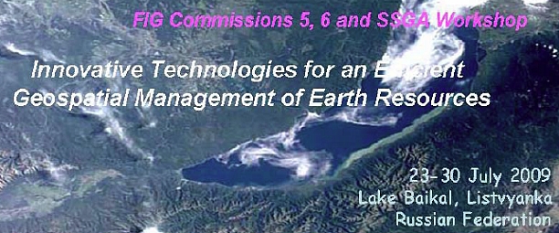
FIG Commissions 5, 6 and SSGA Workshop
“Innovative Technologies for an Efficient Geospatial Management of Earth
Resources”
23-30 July 2009 Lake Baikal, Listvyanka, Russian Federation

Hosted by:
INTERNATIONAL FEDERATION OF SURVEYORS (FIG)
SIBERIAN STATE ACADEMY OF GEODESY (SSGA)
TECHNISCHE UNIVERSITÄT BERLIN (TUB)
IRKUTSK STATE TECHNICAL UNIVERSITY (ISTU)
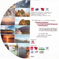
Proceedings
Edited by
Mrs. Argina G. Novitskaya
responsible for editting
E-mail: argina@gmx.de,
argina.novitskaya@gmail.com
The author's right reserved.
Published by the Siberian State Academy of Geodesy (SSGA),
July 2009 ISSN: 978-5-87693-339-3
Printed in Novosibirsk, July 2009
Hard copy of full proceedings
as a .pdf file (10.2 MB, 105 pages)
Изд. лиц. ЛР № 020461 от 04.03.1997.
Подписано в печать 20.07.2009. Формат 60 × 84 1/16
Печать цифровая.
Усл. печ. л. 5,99. Тираж 100 экз.
Заказ .
ГОУ ВПО «Сибирская государственная геодезическая академия»
Отпечатано в
630108, Новосибирск, ул. Плахотного, 8.
|
Sponsors |
|
General sponsor:
Supporteted by:
- The Federal Service of Geodesy and Cartography of Russia (Roskartographia)
- GIS-Association
- Interregional Association “Siberian Agreement”
- Journal “GEOPROFI”, Moscow
- “BaikalGeoService” Research-and-Production company
- JSC “Agency of Tourism and Sport”
|
|
Organising Committee |
Chairman:
Prof. Dr. Lothar Gruendig, Institute of Geodesy and
Geoinformation, Technical University of Berlin, GermanyVice
Chairmen:
Prof. Vladimir A. Seredovich Siberian State Academy of
Geodesy, Russian Federation
Dr. Ivo Milev Technet GmbH, Germany
Co-Chairmen:
Mr. Matt Higgins, Vice President of FIG, Australia
Prof. Anatoli L. Okhotin, President of the Baikal Union of Mining
Surveyors, Head of the Department of Mine Surveying, Irkutsk State
Technical University, Russian Federation
Prof. Eugene M. Medvedev, General Manager, Altex Geomatica Company,
Moscow, Russian Federation
Secretarу:
Mrs. Argina Novitskaya, Manager, Siberian State Academy of
Geodesy, Russian Federation |
|
Proceedings |
|
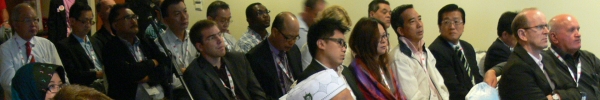
Sunday, 26 July 2009 |
Sunday, 26
July 2009
09:00-09:30
‘Mayak’ Conference Hotel |
Registration of the participants |
Sunday, 26
July 2009
09:30-09:45 |
Opening Ceremony • Greetings by Prof. Dr. Ivan M.
Golovnykh
• Greetings by Prof. Dr. Lothar Gruendig
• Greetings by Prof. Vladimir Seredovich
• Greetings from Mr. Boris I. Ivlev
• Greetings from Dr. Sergey A. Miller
• Greetings by Prof. Anatoli L. Okhotin |
Sunday, 26
July 2009
09:45-11:45 |
Technical Session I
Chair: Prof. Dr. Lothar Gruendig, Technical University of
Berlin, Germany
Vice Chair: Prof. Vladimir A. Seredovich, Siberian State
Academy of
Geodesy, Russian Federation
Co-chairs: Dr. Ivo Milev, Technet GmbH, Germany; Prof.
Anatoli L. Okhotin, President of the Baikal Union of Mining
Surveyors, Head of the Department of Mine Surveying, Irkutsk State
Technical University, Russian Federation; and Prof. Eugeny M.
Medvedev, General Manager, Altex Geomatica Company, Moscow,
Russian Federation
Secretary: Mrs. Argina Novitskaya, SSGA, Novosibirsk, Russian
FederationChristian Clemen and Lothar Gruendig
(Germany):
3D Building Information
Efficiently Acquired and Managed
[
handouts ]
Dr. Ivo Milev (Germany):
EUPOS the Success Guarantee for Rapid
Buildup the Infrastructure in the Countries of Central and Eastern
Europe
[ handouts ]
Daina Morgan (Canada):
Using Mobile Lidar to Survey
Railway Infrastructure. Lynx Mobile Mapper
[ handouts
]
Prof. Vladimir A. Seredovich, Alexander V. Seredovich,
Michael D. Kozoriz (Russian Federation):
Using Laser Scanning for
Estimating Mine Output Volumes and 3D Modelling of Geological
Situation
[
handouts ]
Prof. Vladimir A. Seredovich, Alexander V. Seredovich,
Andrey V. Ivanov, Russian Federation:
Control of Highway and Railway
Construction and Repairs Using Terrestrial Laser Scanning
[ handouts ]
Dr. Albrecht Grimm (Germany):
IGI's Systems for the Efficient Collection of Earth Data
[ handouts ] |
Sunday, 26 July
2009
11:45-12:00 |
Coffee Break |
Sunday, 26 July 2009
12:00-13:30 |
Technical Session 2 Gennady A. Sapozhnikov, Boris
I. Ivlev (Russian Federation):
About Development of Base
Conditions of Formation of Regional Innovative System in Novosibirsk
Region
[ handouts ]
Christian Manthe, Christian Clemen, Lothar
Gruendig (Germany):
Using Oracle Spatial
with Coordinate Systems Based on Any Regional Geodetic Datum
[
handouts ]
Dr. Sergey A. Miller (Russian Federation):
The International Experience and Approaches to the Creation of
Spatial Data Structures. Positioning of the Russian Federation
[ handouts ]
Prof. Anatoli L. Okhotin (Russian Federation):
Application of Laser Scanning in
Mine Surveying
[ handouts
]
Emil Ya. Ostrovsky, Sergej V. Rumyantsev,
Vyacheslav A. Fadeev (Russian Federation):
CS-technology (Consistent Structure Technology) – an Intellectual
Breakthrough in Investigations of Natural Complexes by Digital
Images
[ handouts ] |
Sunday, 26 July
2009
13:30-14:30 |
Lunch |
Sunday, 26 July 2009
14:00-15:30 |
Technical Session 3 Prof. Eugene M. Medvedev
(Russian Federation):
New Features of Airborne Lidar Data
Processing in DTM Generating, Forest Inventory and Civil Engineering
Works
[ handouts
]
Andrey B. Skrepnyuk, Irina G. Guskova (Russian
Federation):
Using Geospatial Data for Implementation of Informational Processes
of
Design Engineering of Gazprom's Facilities: Case History
[
handouts ]
Leonid A. Plastinin, Nadezhda V. Kotelnicova,
Boris N. Olzoev (Russian Federation ):
Cartographical Support
of Steady Development of Tourism on Trans-Border Territories of
Russia and Mongolia
[ handouts ]
Evgeny V. Klevtsov, Valery S. Pankratov (Russian
Federation):
Satellite Monitoring of
Mobile Objects
[ handouts ]
Valery A. Kartashov, Vyacheslav T. Zalutsky
(Russian Federation):
Some Geodetic Technologies of Explorations on the East- Siberian
Railway
[
handouts ]
Anatoly D. Trubchaninov, Olga A. Yagunova (Russian
Federation):
Mining and Environmental
Monitoring of Closed Mines in Kuzbass
[ handouts ] |
Sunday, 26
July 2009
15:30-16:00 |
Coffee Break |
Sunday, 26 July
2009
16:00-17:00 |
Technical Session 4 Vyacheslav T. Zalutsky,
Galina I. Modestova (Russian Federation):
Impact of Irkutsk IGS Station into Geodynamics Phenomena Monitoring
[
handouts ]
Boris N. Olzoev (Russian Federation):
The Electronic Library of Subject
Signs for Recreative and Tourist Maps of Pribaïkal’e
[ handouts ]
Prof. Dr. Alexander P. Karpik (Russian Federation):
The Siberian State Academy of Geodesy
as a Platform for Development and Realization of Information
Technologies for Geodesy, Cartography and Cadastre
[ handouts ]
Irina N. Rotanova, Anna A. Wagner (Russian
Federation):
Basic Spatial Data of Water
Ecological GIS
[ handouts ]
Stanislav Yu Katsko (Russian Federation):
Different Views on a Digital Map in
the Late 20th and the Early 21st Century
[ handouts ] |
Sunday, 26
July 2009
17:00-18:45 |
Round-table discussion Closing Ceremony |
|
