Article of the Month -
March 2014
|
Adjusting Laws to meet the Requirements of Urban
Expansion in a Sus-tainable Property System
Dr. Alexander KOHLI, SWISS LAND MANAGEMENT,
Switzerland
1) The paper of the month
presents a concept for Sustainable Land Management to secure a long term
successful development of informal urbanization. To create good
conditions for improving the property and planning situation, a solid
legal base has to be put in place before further land management
activities are undertaken. The author asks for the initialization of an
intermediate legal frame-work as an initial step to be applied to a
special perimeter of action, the so-called 'temporary development zones'
TDZ. This paper was presented at the Annual World bank Conference on
Land and Poverty, in Washington DC, April 8-1, 2013. You can hear Dr.
Alexander Kohlis presentation at the XXV International FIG Congress 2014
in Kuala Lumpur, Malaysia.
Key words: Urban expansion, land management, fast documentation,
spatial planning, temporary development zones.
ABSTRACT
In metropolitan areas the informal urbanization of the outskirts is a
classic practice. Today it must be accepted that a large number of the
regulatory tools available for managing urban development are not
necessarily appropriate to be applied as they are in many developing and
transitional countries where the rule of law leaves a lot to be desired.
In consequence, the large majority of urban authorities often do not
engage in realistic preparations for growth.
The two known approaches in this field, the set-up of regulatory
measures on the one hand and the public initiatives on the other, are
commonly accepted but do not necessarily lead to success. Looking at the
initiatives approach it becomes clear that the need for a sufficiently
consolidated property system to gain long term success is
underestimated. A formally correct situation without conflicting
property rights and disputed land titles remains a pre-condition not
only for enabling land and housing markets but also in view of securing
land for public needs, assuring sites and services in the framework of
public initiatives (Sustainable Land Management). To create good
conditions for improving the property and planning situation, a solid
legal base has to be put in place before further land management
activities are undertaken.
The presented concept, therefore, asks for the initialization of an
intermediate legal frame-work as an initial step to be applied to a
special perimeter of action, the so-called 'temporary development zones'
TDZ.
1. INTRODUCTION
In metropolitan areas of southern, transitional, or post-conflict
countries, the informal urbanization of the outskirts is a classic
event. Today it must be accepted that a large number, if not most, of
the regulatory tools available for managing urban development in
industrialized countries are not necessarily appropriate in many
southern and transitional countries. Where the rule of law leaves a lot
to be desired, where property rights are not strictly enforced, where
land registration and cadastre are incomplete, where
officially-sanctioned city plans are rarely available or taken
seriously, where much land subdivision and construction happen without
permits, where enforcement is intermittent and often corrupt, and where
a large part of the citizenry cannot afford minimum standard shelter,
new approaches are needed. The large majority of urban authorities in
developing countries do not in consequence often engage in realistic
minimal preparations for growth. It is essential to secure the necessary
public lands and public rights-of-way necessary to serve future urban
growth, protect sensitive lands from building, and invest in minimal
infrastructure—transport grids, water supply, or sewerage and drainage
networks—to accommodate growth that is coherent. Instead, the
authorities some-times focus on ambitious utopian master plans that are
never meant to guide development on the ground, take many years to
complete, and are usually shelved shortly after their publication. At
other times, they simply refuse even minimal planning and investment,
hoping against hope that their overcrowded cities will stop growing.
Even many plans developed with the assistance of donors have neither
been endorsed nor institutionalized. Needless to say, it is more
expensive to provide trunk urban infrastructure in built-up
areas—especially in areas developed by the informal sector—than to
provide such services, or at least to protect the right-of-way needed
for such services, before building takes place. The absence of even
minimal preparation for urban expansion–on both the activist and the
regulatory fronts–is, no doubt, an inefficient, inequitable and
unsustainable practice, imposing great economic and environmental costs
on societies that can ill afford them. For all of these (bad) examples
of urban expansion caused by sprawl and informal/illegal housing and
dwellings, modern concepts of sustainable management are urgently
needed.
The two known approaches in this field, the set-up of regulatory
measures on the one hand and the public initiatives on the other, are
commonly accepted but do not necessarily lead to success. Looking at the
initiatives approach it becomes clear that the need for sufficiently
consolidated property systems to gain long-term success is
underestimated. A formally correct situation without conflicting
property rights and disputed land titles remains a pre-condition not
only for enabling land and housing markets but also for public
initiatives in the sense of securing land for public needs assuring
sites and services. Sustainable land management (SLM) using urban
planning instruments and master plans can reasonably take place to
allocate zones or plots for trade, industry, and housing as well as for
public sites having a formally clear situation concerning property only.
To create good conditions for improving the property and planning
situation a solid legal base has to be put in place before further land
management activities are undertaken.
The key question remains: How can land management be implemented in a
dynamic envi-ronment taking into account economic development, the need
for increasing food and fiber production, as well as preserving
production capabilities and preventing land degradation? How to plan and
manage all uses of land in an integrated manner such that land
management becomes sustainable and supports wellbeing and good
governance? The following findings can be stated as assertions.
Statement 1: Economic development consumes land.
Statement 2: (Sub-)Urban development sprawls on agricultural land.
Statement 3: Land consumption and sprawl cannot be stopped but can be
guided and controlled.
Statement 4: Guidance of land consumption and SLM creates better
conditions for de-velopment.
Statement 5: SLM needs a cadastre as a pre-requisite.
Statement 6: Resolution of informal squatter area problems requires the
establishment of 'temporary development zones' with special legal
provisions.
2. STATEMENT 1: ECONOMIC DEVELOPMENT CONSUMES LAND
As a basic rule it must be accepted that economic growth leads to the
demand for land. This happens in agricultural-based as well as
industrial economies. By 2009 economic growth in Switzerland resulted in
one square metre of land (agricultural ~) being consumed by streets and
buildings every second. With a well defined and permanently monitored
land use plan-ning system in place the consumption of land could not be
hampered. Several towns had to integrate formerly independent villages
as suburbs. Equal results can be found in the megacity of Baku,
Azerbaijan, and Accra, Ghana. There developments combined with migration
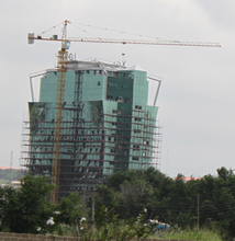
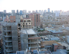
from the land produced a phenomenal construction boom (Figure 2-1).
Figure
2-1 Construction activity in Azerbaijan (2008, left) and Ghana, Accra
(2011, right).
3. STATEMENT 2: (SUB-)URBAN DEVELOPMENT SPRAWLS ON AGRICULTURAL LAND
On all continents, a relative decline in average urban growth rates has
been observed for the last 20 or 30 years, compared to those of the
preceding decades. This declining trend in demographic growth becomes
more obvious if fixed perimeters are used, as a general process of
spatial expansion is being seen everywhere. The advancement of urban
sprawl along communication routes often precedes the type of sprawl
where the empty areas are filled.
Aside from these general forms of urban sprawl, the patterns of
peripheral expansion turn out to be varied in terms of type of housing
conditions, population pattern, means of protecting structures,
construction, and social categories. Despite geographical,
socio-cultural and political situations differing greatly from one
metropolitan area to another, the processes of urban expansion are
similar.
In metropolitan areas of developing or post-conflict countries, the
informal urbanization of the outskirts is a classic working-class
practice. This happens in the form of clandestine housing developments
that fail to comply with the planning regulations, or in the form of
illegal occupation of sites without the owners’ consent, with
inhabitants constructing their own, often precarious, dwellings. This
illegal occupation (e.g. Kosovo (UNCESCR 2008), invasiones in Latin
America, squats or squatter settlements in Asia, campements in Africa,
urbanisation sauvage in Haiti) develops preferentially on available
sites on the city’s outskirts, often un-suitable for habitation. It may
equally occur within gaps in the urban area, including in central or
pericentral zones.
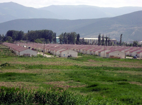
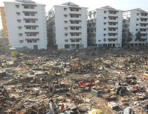
Figure
3-1 Sprawl as a planned development for IDP’s Gardabani near Gori,
Georgia (left) or Gihembe IDP camp, Rwanda (right).
Sprawl may also result from planned development, as demonstrated by
detached housing developments and other residential programs produced by
the capital investment sector or con-trolled by the public sector. Some
projects may be on a very large scale: new districts corresponding to
satellite sub-cities in Delhi, huge metropolitan projects in Bangkok,
edge cities in Cairo, resettlements of IDP’s in Ramana (Baku,
Azerbaijan), Gardabani (Gori, Georgia, Fig-ure 3-1), or Gihembe (Rwanda,
Figure 3-1), etc.
4. STATEMENT 3: LAND CONSUMPTION AND SPRAWL CANNOT BE STOPPED BUT CAN BE
GUIDED AND CONTROLLED
The sustainable treatment of land as a finite resource today is a mayor
goal of space-oriented activities. Against the background and the
requirements of a growing population, the World Bank (2006) defined its
SLM as a knowledge-based procedure that helps integrate land, water,
biodiversity, and environmental management to meet rising food and fiber
demands. This should be achieved through sustaining ecosystem services1
and livelihoods. This definition is focused mainly on agriculture and
rural development. When it comes to urbanized areas the water,
environmental, and biodiversity aspects may take priority.
Bearing in mind Prud’homme et al. (2004) the city itself, based on its
economic role as a fly-wheel, is the moving force for sprawl. The
pressure to repopulate or manage the outskirts problems by legally
approved zoning is mainly dependant on sanitation needs and economic
reasons, as mentioned above. These processes are guided by risk-based
land use planning or prioritized public interest. In non-industrial
countries economic pressure often is overwhelm-ing and dynamic so even
guidance and control do not happen if the relevant instruments are not
in place (UN Habitat 2010). Land consumption, however, declines right
away if the econ-omy shows signs of weakness.
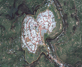
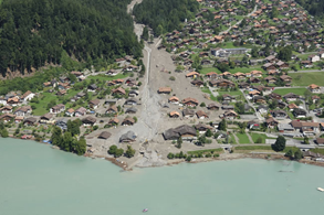
Direction is successful especially if there is danger to be avoided by
risk-based land use planning measures. Hazardous areas such as
floodplains, mud/land and snow slide areas, etc. (Figure 4-1), are not
suitable conditions for housing (Kohli, A. 1999). Even belated
identification can be the reason for resettlement or restricted areas.
In such cases active land use planning becomes SLM and is an asset for
the community by increasing security of life and of investments as well
(Kohli, A., et al. 2001).
1Ecosystem services are the benefits people obtain from ecosystems.
These include: - Provisioning services that provide necessities such as
food, water, timber, and fiber; - Regulating services that affect
climate, floods, disease, wastes, and water quality; - Cultural services
that provide recreational, aesthetic, and spiritual benefits; -
Supporting services such as soil for-mation, photosynthesis, and
nutrient cycling (UNEP 2005).
 |
 |
Figure
4-1 Debris flow in the Bernese Alps, municipality of Brienz (2005,
left), Switzerland and dwellers settle-ment in Port-au-Prince built on a
landslide prone area, Haiti (2010, right, Photo © Ä. Forsman, UN
Habitat).
5. STATEMENT 4: GUIDANCE OF LAND CONSUMPTION AND SLM CREATES BETTER
CONDITIONS FOR DEVELOPMENT
By applying strong SLM procedures, including transparent land
consolidation methods to rural and urbanized areas, amongst other
things, investments in utilities become highly worthwhile and create
more favorable effects than in sprawled areas. Efficiency rates increase
and network planning for water or sewage makes sense. Housing and
industrial site developments as well may profit from available and
easily connected utilities, as these effects can be realized by first
agglomerating construction in abandoned areas, industrial wasteland, or
gaps in settlements. A higher density of users creates better conditions
as overall costs for citizens and capital investors decrease and service
quality may increase.
In Azerbaijan, especially in Baku (Figure 5-1), continuing degradation
of the urban environment is going on due to the lack of a modern spatial
planning system, missing master plans, or absence of detailed plans for
urban areas. Consequently, new construction is carried out under the
pressure of market forces, basically without proper planning
regulations. Even forced eviction for town development is common. In
addition it is not quite clear who is responsible for the preparation of
plans and issuing of permissions for changes in land-use as well as for
building permits. State planning authorities still try to oversee
planning issues that might be handled at the regional or municipal level
(UNECE, Committee on Housing and Land Management 2007). Easy to apply
building permits would help to increase security of the property. Stable
and transparent procedures with defined planning horizons create
security amongst owners and a readiness for dynamic developments — all
factors for the well-being of a developing and an industrial community.
 |
 |
Figure
5-1 Urban construction projects in Baku, Azerbaijan (2008, left), and
urban development with evictions in Borei Keila, Cambodia (2012, right).
6. STATEMENT 5: SLM NEEDS A FAST APPROACH CADASTRE AS A PRE-REQUISITE
Land management needs (in land reform, land consolidation, land use
planning, etc.) as a pre-condition a sustainable base documentation of
topology, topography, and property ownership or tenure. In cases where a
reliable cadastre is missing, property issues remain unclear and SLM is
hampered (The World Bank 2009). So in the immediate aftermath of a
conflict the securing, restoration, or setup of land records is crucial.
The cadastre follows as a consequence of where land records are
available (Augustinus, C., et al. 2007). Bad examples are easy to find,
such as in Kosovo (Andersson, B., et. al. 2003) or other Balkan
countries. Even if a form of a cadastre system is in place but is
unreliable and poorly maintained an unclear property situation makes SLM
very difficult, as shown above in Azerbaijan.
Loss of property and investments because of a lack of transparency in
public planning and an unreliable cadastre will cause distrust in
cadastral documentation. Problems will be created by illegal development
and construction in restricted or endangered areas. Since 2007 in Kosovo
state and municipal authorities have tried to regularize and legalize
illegal constructions as a first step back to reliable land management
systems as the cadastre (UNCESCR 2008).
Recently the call for new tools has been heard. FIG is starting new
initiatives as manifested in the publication Social Tenure Domain Model
(STDM) (Lemmen, Chr. 2010). Unfortunately the data model achieved under
this initiative is even more complicated than others. A more promising
solution is the simplified application of the Cadastre 2014 approach
concentrating on the registration of independent topics for the actual
state of tenures, properties or holdings (Figure 6-1). No surveying is
required but only the identification of property or tenure based on
points, poly-lines, or surfaces is needed. Efforts can be focused on the
time consuming definition for regularization and legalization of
informal and illegal tenures.
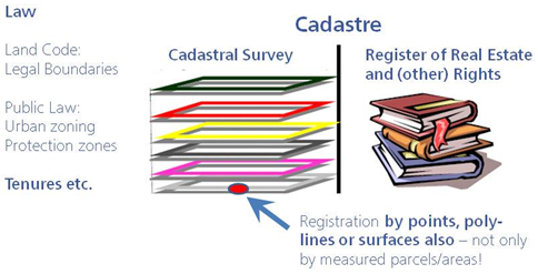
Figure
6-1 Cadastre 2014 data model approach for easy and fast registration of
tenures and holdings besides legal boundaries.
Comprehensive documentation in maintained digital cadastres of the
actual existing legal situation of land following the principle of legal
independence stated by Cadastre 2014 (Kauf-mann, J., Steudler, D., 1998,
page 29, Figure 3.18) will form a strong basis for SLM. The procedure
for fast approach cadastre documentation (Figure 6-2) shall be defined
as follows:
| Step 1: |
Identification of property, house, or tenure on
satellite or ortho-photo maps as point objects to create a
preliminary land title. Definition of a surface description on a
separate cadastre layer in the GIS by poly-lines accepting
overlapping claims, rights, and disputes. The latter shall have
a topological link to the point object forming the land title.
The cadastre information ob-tained in such a way shall reflect
the actual situation should it be legally approved or based on
customary possession. It serves as a working base and needs
stepwise improvement. |
| Step 2: |
Definition of procedures to formalize tenures
based on clear documentation of spatial information. The
procedures have to end up in a legally approved situation. |
| Step 3: |
Further steps focus on the resolution of
conflicts and approval of the property and tenure situation
reflected by the cadastre. As a very easy and effective
procedure the negotiation and reciprocal signing of
(ortho-)photo maps by the owners or holders shall be used. After
this a general public display of the resulting cadastral
documentation may lead to public approval. |
| Step 4: |
Having clear documentation of the actual
situation in the cadastre, the communal and state driven
processes of formalization of ownership or holdings can start by
legally approved land reform acts. |
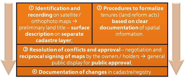
Figure
6-2 Fast Approach Cadastre Documentation to achieve basis for resolving
pending land conflicts.
7. STATEMENT 6: ESTABLISHMENT OF 'TEMPORARY DEVELOPMENT ZONES' TO
RESOLVE SQUATTER PROBLEMS
To overcome the dodgy situation of sprawl combined with informal/illegal
housing and dwellings, a joint approach of land consolidation and urban
planning under special right is recommended. This concept asks for the
initialization of a legal framework dedicated to the development task as
an initial step applying to a separate perimeter of action–so called
'temporary development zones'. From several experiences we learnt that
the adjustment of the legal framework has to take place before any
action of master- and urban-planning, land rights documentation
(cadastre) or regularization action is started. In doing so the
regulations by existing law concerning several fields as civil code,
real estate registration law, cadastre law, land use law, land reform
and privatization law, etc., are arranged and completed to a rule set
(Table 7-1) adapted to the development task under a Governmental Decree
on the Establishment of Temporary Development Zones (TDZ). This rule set
overrides the existing laws mentioned above in specific aspects.
Table 7-1 Legal aspects to be ruled for Temporary Development Zones.
| Civil Code, Real Estate
Registration Law, Cadastre Law: |
Changes to land parcels as well as to rights
(encumbrances) are applicable within TDZ and are registered free
of charge to the new owners. Compensa-tion by the TDZ project.
|
| Land Use Law: |
The land use within TDZ can be changed as
technically accountable. |
| Land Reform Law, Privatization Law: |
Land allocations may be freely changed within
TDZ. |
| Expropriation Law: |
Land expropriation against appropriate
compensation is applicable within TDZ. |
| Building Law: |
New constructions are permitted and registered
free of charge to the new owners. Compensation by the TDZ
project. |
| Public Services Law: |
Public utilities are forced to provide services
and metering to TDZ under appropriate conditions. |
Taking the pre-conditions into account the following process is to be
implemented:
| Step 1: |
Definition of the perimeter of action (dwelling area to be
developed) includ-ing sufficient compensation in adjacent area
or in the near surroundings. |
| Step 2: |
Common agreement and decision on TDZ: The assembly of
stakeholders and local government shall make a decision on the
establishment of special rights for TDZ based on the
Governmental Decree on the Establishment of Temporary
Development Zones (TDZ) for a defined project period. |
| Step 3: |
TDZ Project Analysis Phase: Documentation of formal/informal
land rights, and public demand (services, rights-of-way,
sensitive and endangered lands). |
| Step 4: |
TDZ Project Land Management Phase: Redistribution plan
according to agreed rules of real-substitution and compensation |
| Step 5: |
Public Display of the allocation plan with the right of
administrative appeal for unsatisfied former owners |
| Step 5: |
Registration of new ownership; payments of compensation.
|
| Step 6: |
Reconstruction of settlements by private and utilities by
public entities. |
In running projects, e.g., in Kosovo (Government of the Republic of
Kosovo, MPS 2008) and Azerbaijan, critical factors for success (Kohli,
A. 2004) were identified to be:
-
Documentation of informal/illegal occupation and
construction before regularization;
-
Regularization of informal/illegal occupation
under formal and appropriate compensation to former owners;
-
Management of land and resources according to a
concept developed under the aspects of sustainability;
-
Compulsory land acquisition by the
public–eventually financed by the Bank–in case a direct role in land
development is justifiable (e.g., services, right-of-way) (The World
Bank 2009);
-
Force local government to take an active role
within a very short time; the legal provisions for temporary
development zones shall expire after a limited period;
-
Easy and free of charge registration for new
ownership and building under concurrent compensation for
registration by the TDZ project.
8. CONCLUSIONS
The logical consequence of economic development—the
inevitable consumption of land—substantiates the need for sustainable
land management and cadastre. Successful attempts to direct or manage
land consumption or land use can only be accomplished with the solid
base of a well-maintained digital cadastre following the Cadastre 2014
principles, which represent the actual situation of property and tenure
holdings (fast approach cadastre). The flexibility of handling not only
legally approved but also informal and temporary objects through the use
of the independent layer technology leads to an easy adjustment of
documentation systems to meet the needs for the resolution of land
problems. The sustainable resolution in terms of SLM for squatter and
occupation problems asks for joint approaches of land consolidation and
urban planning under special right. The instrument of 'TEMPORARY
DEVELOPMENT ZONES' is based on a rule set adapted to the development
task under Governmental Decree overruling the relevant land related
laws. This enables a combined implementation of regularization of
informal/illegal property situations and considerable improvements of
services as well as sound legal protection of housing. However, the
approach presented can only work if the Governmental Decree is put in
force before project implementation will happen and the government
allocates substantial funds for compensation.
REFERENCES
Andersson, B., Meha, M. 2003, Land Administration in
Kosovo – Practice in Cooperation and Coordination, UN/ECE-WPLA and FIG
Com3 & Com7 Workshop on Spatial Infor-mation Management (SIM) for
Sustainable Real Estate Market 2003, Athens, Greece.
Augustinus, C., Lewis, D., Leckie, S. 2007, A
Post-Conflict Land Administration and Peace-Building Handbook, Series 1,
UN-HABITAT, http://www.unhabitat.org/pmss/get
ElectronicVersion.aspx?nr=2443&alt=1
Government of the Republic of Kosovo, Ministry of
Public Services 2008, Summary of Find-ings of the KCA Functional Review,
Functional Review and Institutional Design of Minis-tries (FRIDOM)
Project, Pristina, Kosovo.
Kaufmann, J., Steudler, D. with Working Group 7.1 FIG
Commission 7 1998, Cadastre 2014, A Vision for A Future Cadastral
System, FIG Booklet, http://www.swisstopo.ch/fig-wg71/cad2014.htm.
Kohli, A. 1999, Measures to Prevent Scouring of Structures in
Floodplains, Wasser & Boden, 51/3, 40-45 (in German).
Kohli, A. 2004, Reconstruction of a GIS-Cadastre in a
developing Country, GeoSpatial World 2004 Congress, INTERGRAPH, Miami
Beach, Florida, USA.
Kohli, A., Hager, W.H. 2001, Building Scour in
Floodplains, Proceedings of the Institution of Civil Engineers: Water
and Maritime Engineering 148, Issue 2, 61-80.
Lemmen, Chr. 2010, The Social Tenure Domain Model – A
Pro-Poor Land Tool, FIG – GLTN – UN-HABITAT, International Federation of
Surveyors (FIG) Copenhagen, Den-mark.
Prud'homme, R., Dupuy, G. and Boret, D. 2004, The New
Constraints of Urban Development, Institut Veolia Environnement, Report
n°1, Paris, France.
The World Bank 2006, Sustainable Land Management -
Challenges, Opportunities, and Trade-offs, Washington, USA
The World Bank 2009, Systems of Cities, Harnessing
urbanization for growth and poverty alleviation - The World Bank Urban
and Local Government Strategy, Washington, USA
UN Committee on Economic, Social and Cultural Rights (UNCESCR) 2008,
Property Return and Restitution: Kosovo,
http://www2.ohchr.org/english/bodies/cescr/docs/info-ngos/COHREUNMIK.pdf
UNECE-Committee on Housing and Land Management 2007,
Land Administration Review: Azerbaijan, Programme of Work 2008-2009,
Geneva, Switzerland.
UNEP 2005, Millennium Ecosystem Assessment,
Ecosystems and Human Well-being: Gen-eral Synthesis Report,
http://www.unep.org/maweb/en/synthesis.aspx
UN-HABITAT 2010, Strategic Citywide Spatial Planning:
A situational analysis of metro-politan Port-au-Prince, Haiti, Summary
Report, Nairobi, Kenya.
BIOGRAPHICAL NOTES
Dr. Alexander Kohli, born in 1967, graduated
from the Department for Rural Engineering and Surveying in 1995 at the
Swiss Federal Institute of Technology (ETH Zurich). From 1995 until 1998
he was doing his PhD studies at the Versuchsanstalt für Wasserbau (VAW),
Swiss Federal Institute of Technology (ETH Zurich) on BUILDING SCOUR IN
FLOOD PLAINS.
After the PhD in 1998, in 1999 he earned the Swiss
license for licensed land surveyors. With BSB + Partner he runs a
special department for Consulting and Development working for public
(World Bank, EBRD, Swiss Government) and private organizations in the
fields of Project Development, Land Management, Administration and
Cadastre worldwide.
In 2009 Dr. Alexander Kohli was dispatched as the
delegate of the Swiss professional organi-zation of surveyors in FIG to
Commission 8, Spatial Planning and Development. Since 2012 Dr. Kohli
acts as Vice-President of the SWISS LAND MANAGEMENT foundation.
CONTACTS
Dr. Alexander Kohli, Vice-President
SWISS LAND MANAGEMENT
c/o BSB + Partner, Ingenieure und Planer
Leutholdstrasse 4
CH-4562 Biberist, Solothurn
SWITZERLAND
Email:
alexander.kohli@bsb-partner.ch
Web site: www.swisslm.ch
 |